Cresciano geodata
Cresciano (Ticino) is a populated place; located in Switzerland in Europe/Zurich (GMT+2) time zone. With population of 624 people, there are 1670 cities with bigger population in this country. Compared to other cities in Switzerland, 91.5% of cities are located further ↑North; 88.3% of cities are located further ←West and 99% of cities have higher elevation than Cresciano. Note1


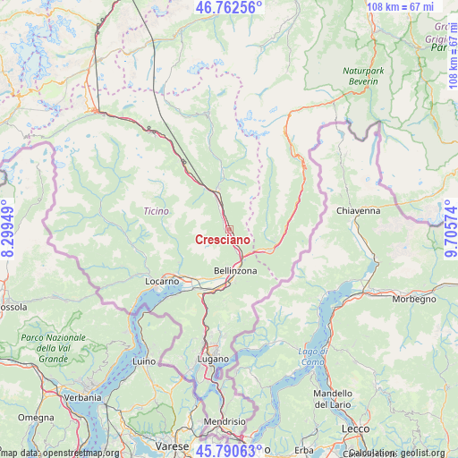
Cresciano GPS coordinates[2]
46° 16' 43.5" North, 9° 0' 9.396" East
| Map corner | latitude | longitude |
|---|---|---|
| Upper-left | 46.76256°, | 8.29949° |
| Center: | 46.27875°, | 9.00261° |
| Lower-right: | 45.79063°, | 9.70574° |
| Map W x H: | 108.1×108.1 km | = 67.2×67.2mi |
| max Lat: | 47.76737° ⇑91.5% North |
| Cresciano: | 46.27875° |
| min Lat: | ⇓8.5% South 45.83203° |
| min Long | Cresciano | max Long |
| 5.97153° | 9.00261° | 10.44624° |
| W 88.3%⇐ | ⇒11.7% E |
Elevation
Elevation of Cresciano is 252 m = 827 ft, and this is 306.2 m = 1005 ft below average elevation for this country.
| Max E: |
1845 m = 6053 ft | 99% |
| Avg. | 558.2 m = 1831 ft | |
| Cresciano | 252 m = 827 ft | |
Min E: |
197 m = 646 ft | 1% |
See also: Switzerland elevation on elevation.city.
Geographical zone
Cresciano is located in North temperate zone (between Tropic of Cancer and the Arctic Circle). Distance of this North polar circle is 2255.5 km =1401.5 mi to North.| Distance of | km | miles | from Cresciano |
|---|---|---|---|
| North Pole | 4861.3 | 3020.7 | to North |
| Arctic Circle | 2255.5 | 1401.5 | to North |
| Tropic Cancer | 2539.8 | 1578.2 | to South |
| Equator | 5145.7 | 3197.4 | to South |


Nearby cities:
15 places around Cresciano: (largest is in red/bold)
• Arvigo
8.9 km =5.5 mi,  72°
72°
• Bellinzona
9.6 km =6 mi,  173°
173°
• Biasca
9.4 km =5.8 mi,  344°
344°
• Braggio
9.7 km =6 mi, 73°
• Buseno
8.1 km =5 mi,  93°
93°
• Claro
2.8 km =1.7 mi,  146°
146°
• Gnosca
5.2 km =3.2 mi,  163°
163°
• Gorduno
7.3 km =4.5 mi, 162°
• Iragna
5.9 km =3.7 mi,  332°
332°
• Lodrino
3 km =1.9 mi,  323°
323°
• Lumino
7.2 km =4.5 mi,  138°
138°
• Monte Carasso
10.3 km =6.4 mi,  181°
181°
• Osogna
3.9 km =2.4 mi, 340°
• San Vittore
9.3 km =5.8 mi,  120°
120°
• Sementina
10.6 km =6.6 mi, 184°
Sources, notices
• [Note1] Compared only with cities in Switzerland existing in our database
• [Src1] Map data: © OpenStreetMap contributors (CC-BY-SA)
• [Src2] Other city data from geonames.org with taken over terms of usage.
• [Src3] Geographical zone / Annual Mean Temperature by Robert A. Rohde @ Wikipedia
