Airolo geodata
Airolo (Ticino) is a populated place; located in Switzerland in Europe/Zurich (GMT+2) time zone. With population of 1,559 people, there are 1002 cities with bigger population in this country. Compared to other cities in Switzerland, 84.6% of cities are located further ↑North; 67.3% of cities are located further ←West and 97% of cities have lower elevation than Airolo. Note1


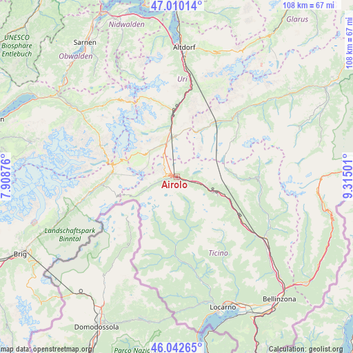
Airolo GPS coordinates[2]
46° 31' 42.78" North, 8° 36' 42.804" East
| Map corner | latitude | longitude |
|---|---|---|
| Upper-left | 47.01014°, | 7.90876° |
| Center: | 46.52855°, | 8.61189° |
| Lower-right: | 46.04265°, | 9.31501° |
| Map W x H: | 107.6×107.6 km | = 66.9×66.9mi |
| max Lat: | 47.76737° ⇑84.6% North |
| Airolo: | 46.52855° |
| min Lat: | ⇓15.4% South 45.83203° |
| min Long | Airolo | max Long |
| 5.97153° | 8.61189° | 10.44624° |
| W 67.3%⇐ | ⇒32.7% E |
Elevation
Elevation of Airolo is 1162 m = 3812 ft, and this is 603.8 m = 1981 ft above average elevation for this country.
| Max E: |
1845 m = 6053 ft | 3% |
| Airolo | 1162 m 3812 ft | |
| Avg. | 558.2 m = 1831 ft | |
Min E: |
197 m = 646 ft | 97% |
See also: Switzerland elevation on elevation.city.
Geographical zone
Airolo is located in North temperate zone (between Tropic of Cancer and the Arctic Circle). Distance of this North polar circle is 2227.7 km =1384.2 mi to North.| Distance of | km | miles | from Airolo |
|---|---|---|---|
| North Pole | 4833.6 | 3003.5 | to North |
| Arctic Circle | 2227.7 | 1384.2 | to North |
| Tropic Cancer | 2567.6 | 1595.4 | to South |
| Equator | 5173.5 | 3214.7 | to South |


Nearby cities:
15 places around Airolo: (largest is in red/bold)
• Acquarossa
26.6 km =16.5 mi,  107°
107°
• Andermatt
12 km =7.5 mi,  353°
353°
• Biasca
33.2 km =20.6 mi,  124°
124°
• Bodio
28.3 km =17.6 mi,  126°
126°
• Cevio
23.8 km =14.8 mi,  181°
181°
• Disentis
26.7 km =16.6 mi,  43°
43°
• Erstfeld
32.4 km =20.1 mi,  5°
5°
• Faido
15.6 km =9.7 mi, 111°
• Giornico
24.5 km =15.2 mi, 125°
• Gordevio
35.1 km =21.8 mi,  163°
163°
• Gurtnellen
23.3 km =14.5 mi,  3°
3°
• Lavertezzo
34.6 km =21.5 mi,  150°
150°
• Maggia
32.1 km =19.9 mi,  166°
166°
• Malvaglia
31.4 km =19.5 mi, 115°
• Silenen
29.3 km =18.2 mi, 9°
Sources, notices
• [Note1] Compared only with cities in Switzerland existing in our database
• [Src1] Map data: © OpenStreetMap contributors (CC-BY-SA)
• [Src2] Other city data from geonames.org with taken over terms of usage.
• [Src3] Geographical zone / Annual Mean Temperature by Robert A. Rohde @ Wikipedia
