Disentis geodata
Disentis (Grisons) is a populated place; located in Switzerland in Europe/Zurich (GMT+2) time zone. With population of 2,193 people, there are 778 cities with bigger population in this country. Compared to other cities in Switzerland, 78.1% of cities are located further ↑North; 83% of cities are located further ←West and 97% of cities have lower elevation than Disentis. Note1


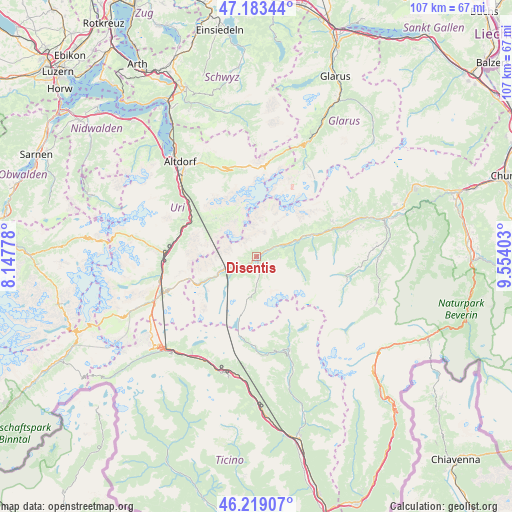
Disentis GPS coordinates[2]
46° 42' 12.276" North, 8° 51' 3.24" East
| Map corner | latitude | longitude |
|---|---|---|
| Upper-left | 47.18344°, | 8.14778° |
| Center: | 46.70341°, | 8.8509° |
| Lower-right: | 46.21907°, | 9.55403° |
| Map W x H: | 107.2×107.2 km | = 66.6×66.6mi |
| max Lat: | 47.76737° ⇑78.1% North |
| Disentis: | 46.70341° |
| min Lat: | ⇓21.9% South 45.83203° |
| min Long | Disentis | max Long |
| 5.97153° | 8.8509° | 10.44624° |
| W 83%⇐ | ⇒17% E |
Elevation
Elevation of Disentis is 1155 m = 3789 ft, and this is 596.8 m = 1958 ft above average elevation for this country.
| Max E: |
1845 m = 6053 ft | 3% |
| Disentis | 1155 m 3789 ft | |
| Avg. | 558.2 m = 1831 ft | |
Min E: |
197 m = 646 ft | 97% |
See also: Switzerland elevation on elevation.city.
Geographical zone
Disentis is located in North temperate zone (between Tropic of Cancer and the Arctic Circle). Distance of this North polar circle is 2208.2 km =1372.1 mi to North.| Distance of | km | miles | from Disentis |
|---|---|---|---|
| North Pole | 4814.1 | 2991.3 | to North |
| Arctic Circle | 2208.2 | 1372.1 | to North |
| Tropic Cancer | 2587 | 1607.5 | to South |
| Equator | 5192.9 | 3226.7 | to South |


Nearby cities:
15 places around Disentis: (largest is in red/bold)
• Altdorf
25.2 km =15.7 mi,  321°
321°
• Andermatt
21 km =13 mi,  248°
248°
• Attinghausen
24.4 km =15.2 mi, 316°
• Breíl
17.6 km =10.9 mi,  65°
65°
• Bürglen
23.8 km =14.8 mi, 323°
• Erstfeld
19.9 km =12.4 mi,  310°
310°
• Faido
25.5 km =15.8 mi,  188°
188°
• Gurtnellen
17.4 km =10.8 mi,  282°
282°
• Obersaxen
19.7 km =12.2 mi, 74°
• Rueun
24.1 km =15 mi, 69°
• Schattdorf
23.4 km =14.5 mi, 320°
• Silenen
16.6 km =10.3 mi, 305°
• Spiringen
20.9 km =13 mi,  333°
333°
• Trun
11.3 km =7 mi, 67°
• Unterschächen
18.8 km =11.7 mi,  340°
340°
Sources, notices
• [Note1] Compared only with cities in Switzerland existing in our database
• [Src1] Map data: © OpenStreetMap contributors (CC-BY-SA)
• [Src2] Other city data from geonames.org with taken over terms of usage.
• [Src3] Geographical zone / Annual Mean Temperature by Robert A. Rohde @ Wikipedia
