Zürich (Kreis 6) / Oberstrass geodata
Zürich (Kreis 6) / Oberstrass (Zurich) is a section of populated place; located in Switzerland in Europe/Zurich (GMT+2) time zone. With population of 9,906 people, there are 153 cities with bigger population in this country. Compared to other cities in Switzerland, 70.9% of cities are located further ↓South; 61.9% of cities are located further ←West and 61.4% of cities have lower elevation than Zürich (Kreis 6) / Oberstrass. Note1
Current local time in Zürich (Kreis 6) / Oberstrass:
08:57 AM, SaturdayDifference from your time zone: hours


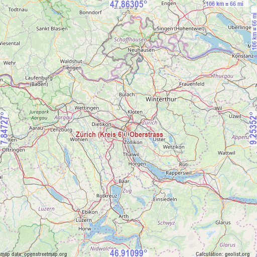
Zürich (Kreis 6) / Oberstrass GPS coordinates[2]
47° 23' 21.012" North, 8° 33' 1.44" East
| Map corner | latitude | longitude |
|---|---|---|
| Upper-left | 47.86305°, | 7.84727° |
| Center: | 47.38917°, | 8.5504° |
| Lower-right: | 46.91099°, | 9.25352° |
| Map W x H: | 105.9×105.9 km | = 65.8×65.8mi |
| max Lat: | 47.76737° ⇑29.1% North |
| Zürich (Kreis 6) / Oberstrass: | 47.38917° |
| min Lat: | ⇓70.9% South 45.83203° |
| min Long | Zürich (Kreis | max Long |
| 5.97153° | 8.5504° | 10.44624° |
| W 61.9%⇐ | ⇒38.1% E |
Elevation
Elevation of Zürich (Kreis 6) / Oberstrass is 527 m = 1729 ft, and this is 31.2 m = 102 ft below average elevation for this country.
| Max E: |
1845 m = 6053 ft | 38.6% |
| Avg. | 558.2 m = 1831 ft | |
| Zürich (Kreis 6) / Oberstrass | 527 m = 1729 ft | |
Min E: |
197 m = 646 ft | 61.4% |
See also: Switzerland elevation on elevation.city.
Geographical zone
Zürich (Kreis 6) / Oberstrass is located in North temperate zone (between Tropic of Cancer and the Arctic Circle). Distance of this North polar circle is 2132 km =1324.8 mi to North.| Distance of | km | miles | from Zürich (Kreis 6) / Oberstrass |
|---|---|---|---|
| North Pole | 4737.9 | 2944 | to North |
| Arctic Circle | 2132 | 1324.8 | to North |
| Tropic Cancer | 2663.3 | 1654.9 | to South |
| Equator | 5269.2 | 3274.1 | to South |


Nearby cities:
15 places around Zürich (Kreis 6) / Oberstrass: (largest is in red/bold)
• Zürich (Kreis 1)
2.2 km =1.4 mi,  197°
197°
• Zürich (Kreis 1) / City
2.1 km =1.3 mi,  211°
211°
• Zürich (Kreis 1) / Lindenhof
2.1 km =1.3 mi, 201°
• Zürich (Kreis 1) / Rathaus
2 km =1.2 mi,  191°
191°
• Zürich (Kreis 10) / Wipkingen
2 km =1.2 mi,  289°
289°
• Zürich (Kreis 11) / Oerlikon
2.2 km =1.4 mi,  344°
344°
• Zürich (Kreis 12)
2.5 km =1.6 mi,  50°
50°
• Zürich (Kreis 12) / Schwamendingen-Mitte
2.5 km =1.6 mi,  41°
41°
• Zürich (Kreis 4) / Langstrasse
2.1 km =1.3 mi,  232°
232°
• Zürich (Kreis 5)
2.2 km =1.4 mi,  265°
265°
• Zürich (Kreis 5) / Gewerbeschule
1.6 km =1 mi,  252°
252°
• Zürich (Kreis 6)
0.6 km =0.4 mi,  304°
304°
• Zürich (Kreis 6) / Unterstrass
1.2 km =0.7 mi, 304°
• Zürich (Kreis 7) / Fluntern
1.3 km =0.8 mi,  140°
140°
• Zürich (Kreis 7) / Hottingen
2.3 km =1.4 mi,  155°
155°
Sources, notices
• [Note1] Compared only with cities in Switzerland existing in our database
• [Src1] Map data: © OpenStreetMap contributors (CC-BY-SA)
• [Src2] Other city data from geonames.org with taken over terms of usage.
• [Src3] Geographical zone / Annual Mean Temperature by Robert A. Rohde @ Wikipedia
