Gockhausen geodata
Gockhausen (Zurich) is a populated place; located in Switzerland in Europe/Zurich (GMT+2) time zone. With population of 1,411 people, there are 1077 cities with bigger population in this country. Compared to other cities in Switzerland, 69.1% of cities are located further ↓South; 66.4% of cities are located further ←West and 69.8% of cities have lower elevation than Gockhausen. Note1


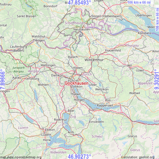
Gockhausen GPS coordinates[2]
47° 22' 51.528" North, 8° 35' 59.208" East
| Map corner | latitude | longitude |
|---|---|---|
| Upper-left | 47.85493°, | 7.89666° |
| Center: | 47.38098°, | 8.59978° |
| Lower-right: | 46.90273°, | 9.30291° |
| Map W x H: | 105.9×105.9 km | = 65.8×65.8mi |
| max Lat: | 47.76737° ⇑30.9% North |
| Gockhausen: | 47.38098° |
| min Lat: | ⇓69.1% South 45.83203° |
| min Long | Gockhausen | max Long |
| 5.97153° | 8.59978° | 10.44624° |
| W 66.4%⇐ | ⇒33.6% E |
Elevation
Elevation of Gockhausen is 572 m = 1877 ft, and this is 13.8 m = 45 ft above average elevation for this country.
| Max E: |
1845 m = 6053 ft | 30.2% |
| Gockhausen | 572 m 1877 ft | |
| Avg. | 558.2 m = 1831 ft | |
Min E: |
197 m = 646 ft | 69.8% |
See also: Switzerland elevation on elevation.city.
Geographical zone
Gockhausen is located in North temperate zone (between Tropic of Cancer and the Arctic Circle). Distance of this North polar circle is 2132.9 km =1325.3 mi to North.| Distance of | km | miles | from Gockhausen |
|---|---|---|---|
| North Pole | 4738.8 | 2944.6 | to North |
| Arctic Circle | 2132.9 | 1325.3 | to North |
| Tropic Cancer | 2662.4 | 1654.3 | to South |
| Equator | 5268.3 | 3273.6 | to South |


Nearby cities:
15 places around Gockhausen: (largest is in red/bold)
• Dübendorf
2.3 km =1.4 mi,  38°
38°
• Dübendorf / Aesch
2.5 km =1.6 mi,  52°
52°
• Dübendorf / Birchlen
2.1 km =1.3 mi,  20°
20°
• Dübendorf / Frickenbuck
2.6 km =1.6 mi,  65°
65°
• Dübendorf / Grüzenstrasse
2 km =1.2 mi, 49°
• Dübendorf / Heugatterstrasse
1.9 km =1.2 mi, 23°
• Dübendorf / Meiershofstrasse
2.2 km =1.4 mi,  30°
30°
• Dübendorf / Neuhausstrasse
2.2 km =1.4 mi, 44°
• Dübendorf / Vogelquartier
1.8 km =1.1 mi, 30°
• Dübendorf / Wasserfurren
1.5 km =0.9 mi, 25°
• Dübendorf / Zelgli
1.8 km =1.1 mi, 39°
• Gockhausen / Meisenrain
0.4 km =0.2 mi,  322°
322°
• Zürich (Kreis 12) / Hirzenbach
2.5 km =1.6 mi,  336°
336°
• Zürich (Kreis 7)
1.7 km =1.1 mi,  239°
239°
• Zürich (Kreis 7) / Looren
1.9 km =1.2 mi,  193°
193°
Sources, notices
• [Note1] Compared only with cities in Switzerland existing in our database
• [Src1] Map data: © OpenStreetMap contributors (CC-BY-SA)
• [Src2] Other city data from geonames.org with taken over terms of usage.
• [Src3] Geographical zone / Annual Mean Temperature by Robert A. Rohde @ Wikipedia
