Punta Arenas geodata
Punta Arenas (Region of Magallanes) is a seat of a first-order administrative division; located in Chile in America/Punta_Arenas (GMT-3) time zone. With population of 117,430 people, there are 24 cities with bigger population in this country. Compared to other cities in Chile, 97.9% of cities are located further ↑North; 73.8% of cities are located further ←West and 77.9% of cities have higher elevation than Punta Arenas. Note1
Administrative division(s):
- Level 1: Region of Magallanes
- Level 2: Provincia de Magallanes
- Level 3: Punta Arenas


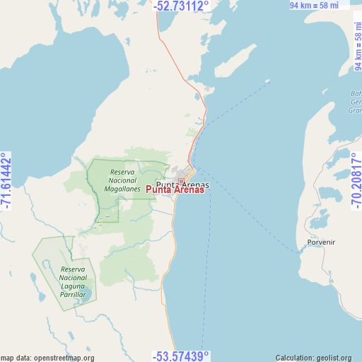
Punta Arenas GPS coordinates[2]
53° 9' 17.388" South, 70° 54' 40.644" West
| Map corner | latitude | longitude |
|---|---|---|
| Upper-left | -52.73112°, | -71.61442° |
| Center: | -53.15483°, | -70.91129° |
| Lower-right: | -53.57439°, | -70.20817° |
| Map W x H: | 93.8×93.8 km | = 58.3×58.3mi |
| max Lat: | -18.19821° ⇑97.9% North |
| Punta Arenas: | -53.15483° |
| min Lat: | ⇓2.1% South -54.93355° |
| min Long | Punta Arenas | max Long |
| -109.42438° | -70.91129° | -67.60963° |
| W 73.8%⇐ | ⇒26.2% E |
Elevation
Elevation of Punta Arenas is 30 m = 98 ft, and this is 243 m = 797 ft below average elevation for this country.
| Max E: |
3544 m = 11627 ft | 77.9% |
| Avg. | 273 m = 896 ft | |
| Punta Arenas | 30 m = 98 ft | |
Min E: |
1 m = 3 ft | 22.1% |
See also: Punta Arenas elevation on elevation.city.
Geographical zone
Punta Arenas is located in South temperate zone (between Tropic of Capricorn and the Antarctic Circle). Distance of this South polar circle is 1490.9 km =926.4 mi to South.| Distance of | km | miles | from Punta Arenas |
|---|---|---|---|
| Equator | 5910.3 | 3672.5 | to North |
| Tropic Capricorn | 3304.3 | 2053.2 | to North |
| Antarctic Circle | 1490.9 | 926.4 | to South |
| South Pole | 4096.8 | 2545.6 | to South |


Nearby cities:
4 places around Punta Arenas: (largest is in red/bold)
• Cámeron
99.7 km =62 mi,  122°
122°
• Porvenir
39.5 km =24.5 mi,  113°
113°
• Puerto Natales
191.8 km =119.2 mi,  325°
325°
• Puerto Williams
292.5 km =181.8 mi,  132°
132°
Sources, notices
• [Note1] Compared only with cities in Chile existing in our database
• [Src1] Map data: © OpenStreetMap contributors (CC-BY-SA)
• [Src2] Other city data from geonames.org with taken over terms of usage.
• [Src3] Geographical zone / Annual Mean Temperature by Robert A. Rohde @ Wikipedia
