Zhuji geodata
Zhuji (Zhejiang) is a seat of a third-order administrative division; located in China in Asia/Shanghai (GMT+8) time zone. With population of 110,721 people, there are 392 cities with bigger population in this country. Compared to other cities in China, 57.2% of cities are located further ↑North; 83.5% of cities are located further ←West and 81.6% of cities have higher elevation than Zhuji. Note1


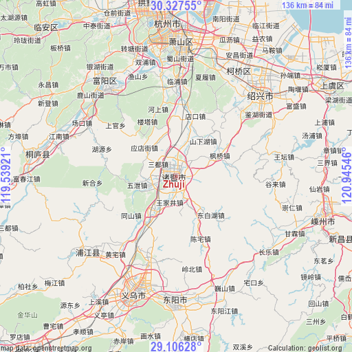
Zhuji GPS coordinates[2]
29° 43' 7.572" North, 120° 14' 32.388" East
| Map corner | latitude | longitude |
|---|---|---|
| Upper-left | 30.32755°, | 119.53921° |
| Center: | 29.71877°, | 120.24233° |
| Lower-right: | 29.10628°, | 120.94546° |
| Map W x H: | 135.8×135.8 km | = 84.4×84.4mi |
| max Lat: | 53.31946° ⇑57.2% North |
| Zhuji: | 29.71877° |
| min Lat: | ⇓42.8% South 18.22056° |
| min Long | Zhuji | max Long |
| 75.07348° | 120.24233° | 134.28917° |
| W 83.5%⇐ | ⇒16.5% E |
Elevation
Elevation of Zhuji is 23 m = 75 ft, and this is 461.8 m = 1515 ft below average elevation for this country.
| Max E: |
5622 m = 18445 ft | 81.6% |
| Avg. | 484.8 m = 1591 ft | |
| Zhuji | 23 m = 75 ft | |
Min E: |
-3 m = -10 ft | 18.4% |
See also: Zhuji elevation on elevation.city.
Geographical zone
Zhuji is located in North temperate zone (between Tropic of Cancer and the Arctic Circle). Distance of this Northern Tropic circle is 698.5 km =434 mi to South.| Distance of | km | miles | from Zhuji |
|---|---|---|---|
| North Pole | 6702.6 | 4164.8 | to North |
| Arctic Circle | 4096.8 | 2545.6 | to North |
| Tropic Cancer | 698.5 | 434 | to South |
| Equator | 3304.4 | 2053.3 | to South |


Nearby cities:
15 places around Zhuji: (largest is in red/bold)
• Caota
11.2 km =7 mi,  249°
249°
• Chencai
19.8 km =12.3 mi,  138°
138°
• Datang’an
8.1 km =5 mi, 248°
• Fengqiao
18.5 km =11.5 mi,  64°
64°
• Huangshan
18 km =11.2 mi,  153°
153°
• Jiangzao
15.4 km =9.6 mi,  27°
27°
• Jieting
8.7 km =5.4 mi,  161°
161°
• Lipu
15.4 km =9.6 mi, 139°
• Paitou
15.3 km =9.5 mi,  215°
215°
• Shanxiahu
18.7 km =11.6 mi, 34°
• Shixiang
15.6 km =9.7 mi,  257°
257°
• Wangjiajing
10.5 km =6.5 mi,  194°
194°
• Yingdianjie
16.5 km =10.3 mi,  311°
311°
• Zhaojia
21.1 km =13.1 mi,  78°
78°
• Zhibu
11.3 km =7 mi,  2°
2°
Sources, notices
• [Note1] Compared only with cities in China existing in our database
• [Src1] Map data: © OpenStreetMap contributors (CC-BY-SA)
• [Src2] Other city data from geonames.org with taken over terms of usage.
• [Src3] Geographical zone / Annual Mean Temperature by Robert A. Rohde @ Wikipedia
