Datang’an geodata
Datang’an (Zhejiang) is a seat of a fourth-order administrative division; located in China in Asia/Shanghai (GMT+8) time zone. In our database, there are 1268 cities with bigger population. Compared to other cities in China, 57.6% of cities are located further ↑North; 83% of cities are located further ←West and 80.2% of cities have higher elevation than Datang’an. Note1


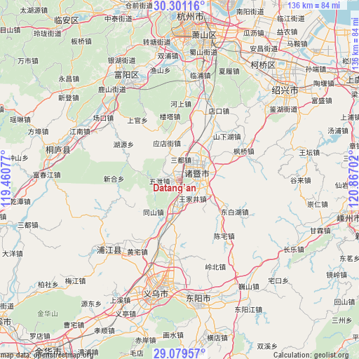
Datang’an GPS coordinates[2]
29° 41' 31.992" North, 120° 9' 50.004" East
| Map corner | latitude | longitude |
|---|---|---|
| Upper-left | 30.30116°, | 119.46077° |
| Center: | 29.69222°, | 120.16389° |
| Lower-right: | 29.07957°, | 120.86702° |
| Map W x H: | 135.8×135.8 km | = 84.4×84.4mi |
| max Lat: | 53.31946° ⇑57.6% North |
| Datang’an: | 29.69222° |
| min Lat: | ⇓42.4% South 18.22056° |
| min Long | Datang’an | max Long |
| 75.07348° | 120.16389° | 134.28917° |
| W 83%⇐ | ⇒17% E |
Elevation
Elevation of Datang’an is 26 m = 85 ft, and this is 458.8 m = 1505 ft below average elevation for this country.
| Max E: |
5622 m = 18445 ft | 80.2% |
| Avg. | 484.8 m = 1591 ft | |
| Datang’an | 26 m = 85 ft | |
Min E: |
-3 m = -10 ft | 19.8% |
See also: China elevation on elevation.city.
Geographical zone
Datang’an is located in North temperate zone (between Tropic of Cancer and the Arctic Circle). Distance of this Northern Tropic circle is 695.5 km =432.2 mi to South.| Distance of | km | miles | from Datang’an |
|---|---|---|---|
| North Pole | 6705.6 | 4166.7 | to North |
| Arctic Circle | 4099.7 | 2547.4 | to North |
| Tropic Cancer | 695.5 | 432.2 | to South |
| Equator | 3301.5 | 2051.5 | to South |


Nearby cities:
15 places around Datang’an: (largest is in red/bold)
• Anhua
15.6 km =9.7 mi,  197°
197°
• Caota
3.1 km =1.9 mi,  251°
251°
• Chencai
23.9 km =14.9 mi,  120°
120°
• Gaochengtou
15.7 km =9.8 mi,  219°
219°
• Huangshan
20.4 km =12.7 mi,  130°
130°
• Jiangzao
22.1 km =13.7 mi,  41°
41°
• Jieting
11.6 km =7.2 mi, 117°
• Lipu
19.7 km =12.2 mi, 116°
• Paitou
9.6 km =6 mi,  187°
187°
• Shixiang
7.6 km =4.7 mi,  266°
266°
• Tanxi
22.5 km =14 mi, 251°
• Wangjiajing
8.7 km =5.4 mi,  145°
145°
• Yingdianjie
14.7 km =9.1 mi,  340°
340°
• Zhibu
16.4 km =10.2 mi,  29°
29°
• Zhuji
8.1 km =5 mi,  68°
68°
Sources, notices
• [Note1] Compared only with cities in China existing in our database
• [Src1] Map data: © OpenStreetMap contributors (CC-BY-SA)
• [Src2] Other city data from geonames.org with taken over terms of usage.
• [Src3] Geographical zone / Annual Mean Temperature by Robert A. Rohde @ Wikipedia
