Zhapu geodata
Zhapu (Zhejiang) is a seat of a fourth-order administrative division; located in China in Asia/Shanghai (GMT+8) time zone. In our database, there are 1268 cities with bigger population. Compared to other cities in China, 51.2% of cities are located further ↓South; 88.1% of cities are located further ←West and 88.7% of cities have higher elevation than Zhapu. Note1


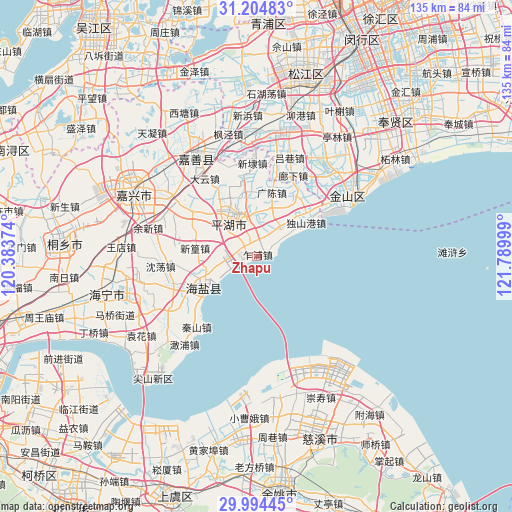
Zhapu GPS coordinates[2]
30° 36' 5.508" North, 121° 5' 12.696" East
| Map corner | latitude | longitude |
|---|---|---|
| Upper-left | 31.20483°, | 120.38374° |
| Center: | 30.60153°, | 121.08686° |
| Lower-right: | 29.99445°, | 121.78999° |
| Map W x H: | 134.6×134.6 km | = 83.6×83.6mi |
| max Lat: | 53.31946° ⇑48.8% North |
| Zhapu: | 30.60153° |
| min Lat: | ⇓51.2% South 18.22056° |
| min Long | Zhapu | max Long |
| 75.07348° | 121.08686° | 134.28917° |
| W 88.1%⇐ | ⇒11.9% E |
Elevation
Elevation of Zhapu is 11 m = 36 ft, and this is 473.8 m = 1554 ft below average elevation for this country.
| Max E: |
5622 m = 18445 ft | 88.7% |
| Avg. | 484.8 m = 1591 ft | |
| Zhapu | 11 m = 36 ft | |
Min E: |
-3 m = -10 ft | 11.3% |
See also: China elevation on elevation.city.
Geographical zone
Zhapu is located in North temperate zone (between Tropic of Cancer and the Arctic Circle). Distance of this Northern Tropic circle is 796.7 km =495 mi to South.| Distance of | km | miles | from Zhapu |
|---|---|---|---|
| North Pole | 6604.5 | 4103.8 | to North |
| Arctic Circle | 3998.6 | 2484.6 | to North |
| Tropic Cancer | 796.7 | 495 | to South |
| Equator | 3402.6 | 2114.3 | to South |


Nearby cities:
15 places around Zhapu: (largest is in red/bold)
• Caoqiao
13.8 km =8.6 mi,  304°
304°
• Dayun
24.2 km =15 mi,  326°
326°
• Fengqiao
23.2 km =14.4 mi,  286°
286°
• Guangchen
17.2 km =10.7 mi,  12°
12°
• Huxiaoqiao
10.2 km =6.3 mi,  41°
41°
• Linjiadai
6 km =3.7 mi, 10°
• Qianxu Zhen
24.5 km =15.2 mi, 37°
• Qinshan
24.3 km =15.1 mi,  220°
220°
• Quantang
15.9 km =9.9 mi,  55°
55°
• Wuyuan
16.3 km =10.1 mi,  234°
234°
• Xincang
16.8 km =10.4 mi,  30°
30°
• Xinfeng
20.1 km =12.5 mi,  306°
306°
• Xinhuang
16.6 km =10.3 mi,  277°
277°
• Xitangqiao
10 km =6.2 mi,  274°
274°
• Yucheng
23.6 km =14.7 mi,  251°
251°
Sources, notices
• [Note1] Compared only with cities in China existing in our database
• [Src1] Map data: © OpenStreetMap contributors (CC-BY-SA)
• [Src2] Other city data from geonames.org with taken over terms of usage.
• [Src3] Geographical zone / Annual Mean Temperature by Robert A. Rohde @ Wikipedia
