Quantang geodata
Quantang (Zhejiang) is a seat of a fourth-order administrative division; located in China in Asia/Shanghai (GMT+8) time zone. In our database, there are 1268 cities with bigger population. Compared to other cities in China, 51.9% of cities are located further ↓South; 88.7% of cities are located further ←West and 91.2% of cities have higher elevation than Quantang. Note1


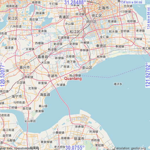
Quantang GPS coordinates[2]
30° 40' 55.488" North, 121° 13' 26.004" East
| Map corner | latitude | longitude |
|---|---|---|
| Upper-left | 31.28488°, | 120.52077° |
| Center: | 30.68208°, | 121.22389° |
| Lower-right: | 30.0755°, | 121.92702° |
| Map W x H: | 134.5×134.5 km | = 83.6×83.6mi |
| max Lat: | 53.31946° ⇑48.1% North |
| Quantang: | 30.68208° |
| min Lat: | ⇓51.9% South 18.22056° |
| min Long | Quantang | max Long |
| 75.07348° | 121.22389° | 134.28917° |
| W 88.7%⇐ | ⇒11.3% E |
Elevation
Elevation of Quantang is 9 m = 30 ft, and this is 475.8 m = 1561 ft below average elevation for this country.
| Max E: |
5622 m = 18445 ft | 91.2% |
| Avg. | 484.8 m = 1591 ft | |
| Quantang | 9 m = 30 ft | |
Min E: |
-3 m = -10 ft | 8.8% |
See also: China elevation on elevation.city.
Geographical zone
Quantang is located in North temperate zone (between Tropic of Cancer and the Arctic Circle). Distance of this Northern Tropic circle is 805.6 km =500.6 mi to South.| Distance of | km | miles | from Quantang |
|---|---|---|---|
| North Pole | 6595.5 | 4098.3 | to North |
| Arctic Circle | 3989.6 | 2479 | to North |
| Tropic Cancer | 805.6 | 500.6 | to South |
| Equator | 3411.5 | 2119.8 | to South |


Nearby cities:
15 places around Quantang: (largest is in red/bold)
• Caoqiao
24.4 km =15.2 mi,  267°
267°
• Guangchen
12.2 km =7.6 mi,  309°
309°
• Huxiaoqiao
6.5 km =4 mi,  258°
258°
• Jinshanwei
9.8 km =6.1 mi,  62°
62°
• Linjiadai
12.4 km =7.7 mi, 255°
• Lüxiang
17.2 km =10.7 mi,  342°
342°
• Qianxu Zhen
10.7 km =6.6 mi,  9°
9°
• Shanyang
16.7 km =10.4 mi, 55°
• Xincang
7.2 km =4.5 mi,  320°
320°
• Xindai
20.7 km =12.9 mi, 319°
• Xitangqiao
24.5 km =15.2 mi,  250°
250°
• Zhangyan
14.9 km =9.3 mi,  21°
21°
• Zhapu
15.9 km =9.9 mi,  235°
235°
• Zhuangxing
21.6 km =13.4 mi,  29°
29°
• Zhujing
25.1 km =15.6 mi,  345°
345°
Sources, notices
• [Note1] Compared only with cities in China existing in our database
• [Src1] Map data: © OpenStreetMap contributors (CC-BY-SA)
• [Src2] Other city data from geonames.org with taken over terms of usage.
• [Src3] Geographical zone / Annual Mean Temperature by Robert A. Rohde @ Wikipedia
