Yuxia geodata
Yuxia (Shaanxi) is a seat of a fourth-order administrative division; located in China in Asia/Shanghai (GMT+8) time zone. With population of 60,206 people, there are 728 cities with bigger population in this country. Compared to other cities in China, 70.4% of cities are located further ↓South; 78% of cities are located further →East and 70.9% of cities have lower elevation than Yuxia. Note1


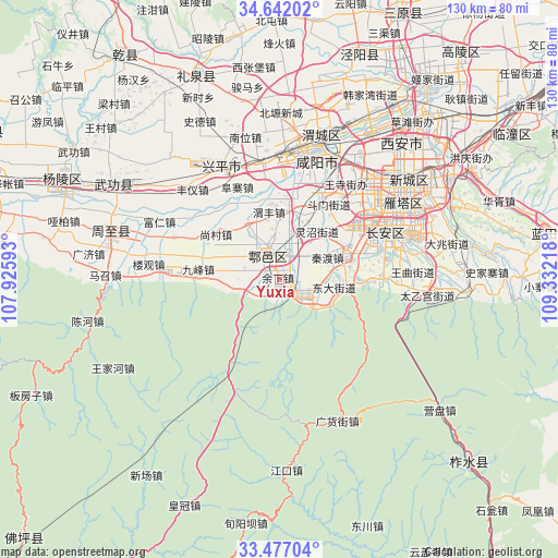
Yuxia GPS coordinates[2]
34° 3' 41.508" North, 108° 37' 44.58" East
| Map corner | latitude | longitude |
|---|---|---|
| Upper-left | 34.64202°, | 107.92593° |
| Center: | 34.06153°, | 108.62905° |
| Lower-right: | 33.47704°, | 109.33218° |
| Map W x H: | 129.5×129.5 km | = 80.5×80.5mi |
| max Lat: | 53.31946° ⇑29.6% North |
| Yuxia: | 34.06153° |
| min Lat: | ⇓70.4% South 18.22056° |
| min Long | Yuxia | max Long |
| 75.07348° | 108.62905° | 134.28917° |
| W 22%⇐ | ⇒78% E |
Elevation
Elevation of Yuxia is 428 m = 1404 ft, and this is 56.8 m = 186 ft below average elevation for this country.
| Max E: |
5622 m = 18445 ft | 29.1% |
| Avg. | 484.8 m = 1591 ft | |
| Yuxia | 428 m = 1404 ft | |
Min E: |
-3 m = -10 ft | 70.9% |
See also: Yuxia elevation on elevation.city.
Geographical zone
Yuxia is located in North temperate zone (between Tropic of Cancer and the Arctic Circle). Distance of this Northern Tropic circle is 1181.4 km =734.1 mi to South.| Distance of | km | miles | from Yuxia |
|---|---|---|---|
| North Pole | 6219.8 | 3864.8 | to North |
| Arctic Circle | 3613.9 | 2245.6 | to North |
| Tropic Cancer | 1181.4 | 734.1 | to South |
| Equator | 3787.3 | 2353.3 | to South |


Nearby cities:
15 places around Yuxia: (largest is in red/bold)
• Cangyou
11.5 km =7.1 mi,  11°
11°
• Caotang
7.8 km =4.8 mi,  104°
104°
• Dongda
13 km =8.1 mi, 98°
• Ganhe
15 km =9.3 mi,  315°
315°
• Ganting
4.8 km =3 mi,  343°
343°
• Jiangcun
14.5 km =9 mi,  279°
279°
• Laodian
13.6 km =8.5 mi,  333°
333°
• Pangguang
4.7 km =2.9 mi,  140°
140°
• Qindu
12.1 km =7.5 mi,  67°
67°
• Shijing
5.2 km =3.2 mi,  225°
225°
• Tianqiao
6.2 km =3.9 mi,  260°
260°
• Weifeng
14.9 km =9.3 mi,  354°
354°
• Wuxing
14.9 km =9.3 mi,  88°
88°
• Wuzhu
6.3 km =3.9 mi,  24°
24°
• Zu’an
13.8 km =8.6 mi,  285°
285°
Sources, notices
• [Note1] Compared only with cities in China existing in our database
• [Src1] Map data: © OpenStreetMap contributors (CC-BY-SA)
• [Src2] Other city data from geonames.org with taken over terms of usage.
• [Src3] Geographical zone / Annual Mean Temperature by Robert A. Rohde @ Wikipedia
