Caotang geodata
Caotang (Shaanxi) is a seat of a fourth-order administrative division; located in China in Asia/Shanghai (GMT+8) time zone. In our database, there are 1268 cities with bigger population. Compared to other cities in China, 70.2% of cities are located further ↓South; 77.6% of cities are located further →East and 71% of cities have lower elevation than Caotang. Note1


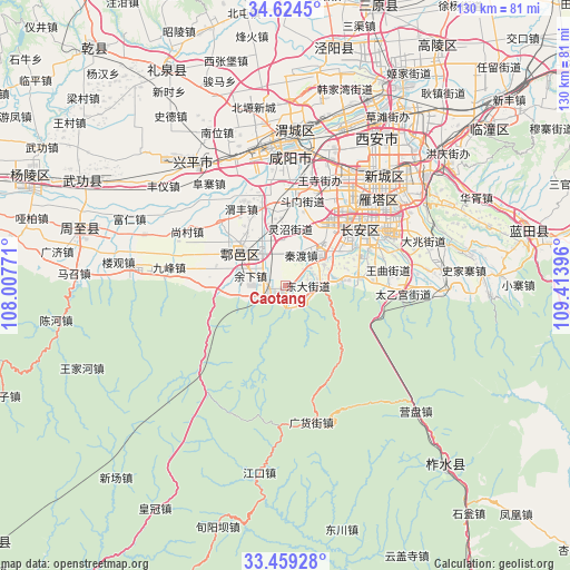
Caotang GPS coordinates[2]
34° 2' 38.004" North, 108° 42' 38.988" East
| Map corner | latitude | longitude |
|---|---|---|
| Upper-left | 34.6245°, | 108.00771° |
| Center: | 34.04389°, | 108.71083° |
| Lower-right: | 33.45928°, | 109.41396° |
| Map W x H: | 129.6×129.6 km | = 80.5×80.5mi |
| max Lat: | 53.31946° ⇑29.8% North |
| Caotang: | 34.04389° |
| min Lat: | ⇓70.2% South 18.22056° |
| min Long | Caotang | max Long |
| 75.07348° | 108.71083° | 134.28917° |
| W 22.4%⇐ | ⇒77.6% E |
Elevation
Elevation of Caotang is 429 m = 1407 ft, and this is 55.8 m = 183 ft below average elevation for this country.
| Max E: |
5622 m = 18445 ft | 29% |
| Avg. | 484.8 m = 1591 ft | |
| Caotang | 429 m = 1407 ft | |
Min E: |
-3 m = -10 ft | 71% |
See also: China elevation on elevation.city.
Geographical zone
Caotang is located in North temperate zone (between Tropic of Cancer and the Arctic Circle). Distance of this Northern Tropic circle is 1179.4 km =732.8 mi to South.| Distance of | km | miles | from Caotang |
|---|---|---|---|
| North Pole | 6221.7 | 3866 | to North |
| Arctic Circle | 3615.8 | 2246.8 | to North |
| Tropic Cancer | 1179.4 | 732.8 | to South |
| Equator | 3785.3 | 2352.1 | to South |


Nearby cities:
15 places around Caotang: (largest is in red/bold)
• Cangyou
14.2 km =8.8 mi,  338°
338°
• Dongda
5.3 km =3.3 mi,  89°
89°
• Ganting
11 km =6.8 mi,  306°
306°
• Luanzhen
9.4 km =5.8 mi,  80°
80°
• Mawang
17.8 km =11.1 mi,  0°
0°
• Pangguang
4.8 km =3 mi,  249°
249°
• Qindu
7.5 km =4.7 mi,  29°
29°
• Shijing
11.4 km =7.1 mi,  261°
261°
• Tianqiao
13.7 km =8.5 mi,  273°
273°
• Wuxing
7.8 km =4.8 mi,  71°
71°
• Wuzhu
9.1 km =5.7 mi,  327°
327°
• Xiliu
13.9 km =8.6 mi, 31°
• Xinglong
13.3 km =8.3 mi,  47°
47°
• Yuxia
7.8 km =4.8 mi,  284°
284°
• Ziwu
16.9 km =10.5 mi, 84°
Sources, notices
• [Note1] Compared only with cities in China existing in our database
• [Src1] Map data: © OpenStreetMap contributors (CC-BY-SA)
• [Src2] Other city data from geonames.org with taken over terms of usage.
• [Src3] Geographical zone / Annual Mean Temperature by Robert A. Rohde @ Wikipedia
