Yuhua geodata
Yuhua (Jiangsu) is a seat of a fourth-order administrative division; located in China in Asia/Shanghai (GMT+8) time zone. In our database, there are 1268 cities with bigger population. Compared to other cities in China, 67% of cities are located further ↓South; 85.3% of cities are located further ←West and 97.2% of cities have higher elevation than Yuhua. Note1


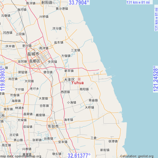
Yuhua GPS coordinates[2]
33° 12' 14.616" North, 120° 32' 31.74" East
| Map corner | latitude | longitude |
|---|---|---|
| Upper-left | 33.7904°, | 119.83903° |
| Center: | 33.20406°, | 120.54215° |
| Lower-right: | 32.61377°, | 121.24528° |
| Map W x H: | 130.8×130.8 km | = 81.3×81.3mi |
| max Lat: | 53.31946° ⇑33% North |
| Yuhua: | 33.20406° |
| min Lat: | ⇓67% South 18.22056° |
| min Long | Yuhua | max Long |
| 75.07348° | 120.54215° | 134.28917° |
| W 85.3%⇐ | ⇒14.7% E |
Elevation
Elevation of Yuhua is 5 m = 16 ft, and this is 479.8 m = 1574 ft below average elevation for this country.
| Max E: |
5622 m = 18445 ft | 97.2% |
| Avg. | 484.8 m = 1591 ft | |
| Yuhua | 5 m = 16 ft | |
Min E: |
-3 m = -10 ft | 2.8% |
See also: China elevation on elevation.city.
Geographical zone
Yuhua is located in North temperate zone (between Tropic of Cancer and the Arctic Circle). Distance of this Northern Tropic circle is 1086 km =674.8 mi to South.| Distance of | km | miles | from Yuhua |
|---|---|---|---|
| North Pole | 6315.1 | 3924 | to North |
| Arctic Circle | 3709.2 | 2304.8 | to North |
| Tropic Cancer | 1086 | 674.8 | to South |
| Equator | 3691.9 | 2294 | to South |


Nearby cities:
15 places around Yuhua: (largest is in red/bold)
• Baiju
26.6 km =16.5 mi,  235°
235°
• Caomiao
20.8 km =12.9 mi,  145°
145°
• Daqiao
25 km =15.5 mi,  159°
159°
• Dazhong
7.9 km =4.9 mi,  266°
266°
• Fangqiang
22.3 km =13.9 mi,  331°
331°
• Haifeng
34.6 km =21.5 mi,  194°
194°
• Hechen
36 km =22.4 mi,  232°
232°
• Liuzhuang
24.3 km =15.1 mi,  252°
252°
• Nanyang
9.5 km =5.9 mi, 154°
• Sanlong
24 km =14.9 mi,  353°
353°
• Touzao
35 km =21.7 mi,  178°
178°
• Wanying
17.5 km =10.9 mi,  171°
171°
• Xiaohai
20.4 km =12.7 mi,  197°
197°
• Xinfeng
10.9 km =6.8 mi,  310°
310°
• Xituan
15.6 km =9.7 mi, 227°
Sources, notices
• [Note1] Compared only with cities in China existing in our database
• [Src1] Map data: © OpenStreetMap contributors (CC-BY-SA)
• [Src2] Other city data from geonames.org with taken over terms of usage.
• [Src3] Geographical zone / Annual Mean Temperature by Robert A. Rohde @ Wikipedia
