Yangdun geodata
Yangdun (Fujian) is a seat of a fourth-order administrative division; located in China in Asia/Shanghai (GMT+8) time zone. In our database, there are 1268 cities with bigger population. Compared to other cities in China, 78.5% of cities are located further ↑North; 70.1% of cities are located further ←West and 52.7% of cities have lower elevation than Yangdun. Note1


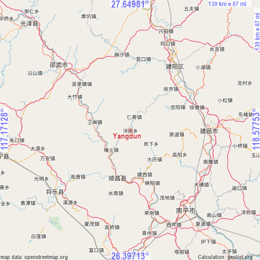
Yangdun GPS coordinates[2]
27° 1' 30.792" North, 117° 52' 27.84" East
| Map corner | latitude | longitude |
|---|---|---|
| Upper-left | 27.64981°, | 117.17128° |
| Center: | 27.02522°, | 117.8744° |
| Lower-right: | 26.39713°, | 118.57753° |
| Map W x H: | 139.3×139.3 km | = 86.6×86.6mi |
| max Lat: | 53.31946° ⇑78.5% North |
| Yangdun: | 27.02522° |
| min Lat: | ⇓21.5% South 18.22056° |
| min Long | Yangdun | max Long |
| 75.07348° | 117.8744° | 134.28917° |
| W 70.1%⇐ | ⇒29.9% E |
Elevation
Elevation of Yangdun is 186 m = 610 ft, and this is 298.8 m = 980 ft below average elevation for this country.
| Max E: |
5622 m = 18445 ft | 47.3% |
| Avg. | 484.8 m = 1591 ft | |
| Yangdun | 186 m = 610 ft | |
Min E: |
-3 m = -10 ft | 52.7% |
See also: China elevation on elevation.city.
Geographical zone
Yangdun is located in North temperate zone (between Tropic of Cancer and the Arctic Circle). Distance of this Northern Tropic circle is 399 km =247.9 mi to South.| Distance of | km | miles | from Yangdun |
|---|---|---|---|
| North Pole | 7002.1 | 4350.9 | to North |
| Arctic Circle | 4396.3 | 2731.7 | to North |
| Tropic Cancer | 399 | 247.9 | to South |
| Equator | 3004.9 | 1867.2 | to South |


Nearby cities:
15 places around Yangdun: (largest is in red/bold)
• Dagan
17.5 km =10.9 mi,  233°
233°
• Dalikou
19.7 km =12.2 mi,  139°
139°
• Gaotang
37.7 km =23.4 mi, 229°
• Hongdun
21.3 km =13.2 mi,  255°
255°
• Jianxi
24.6 km =15.3 mi,  161°
161°
• Jihui
19.5 km =12.1 mi,  173°
173°
• Jiyang
28.5 km =17.7 mi,  63°
63°
• Lanxia
13.1 km =8.1 mi,  123°
123°
• Pushang
14.5 km =9 mi, 225°
• Shuinan
34.3 km =21.3 mi,  193°
193°
• Xiayang
30.4 km =18.9 mi, 157°
• Xushi
31 km =19.3 mi,  43°
43°
• Yangkou
25.1 km =15.6 mi, 174°
• Yedun
29.4 km =18.3 mi, 115°
• Yuankeng
33.5 km =20.8 mi,  208°
208°
Sources, notices
• [Note1] Compared only with cities in China existing in our database
• [Src1] Map data: © OpenStreetMap contributors (CC-BY-SA)
• [Src2] Other city data from geonames.org with taken over terms of usage.
• [Src3] Geographical zone / Annual Mean Temperature by Robert A. Rohde @ Wikipedia
