Hongdun geodata
Hongdun (Fujian) is a seat of a fourth-order administrative division; located in China in Asia/Shanghai (GMT+8) time zone. In our database, there are 1268 cities with bigger population. Compared to other cities in China, 78.7% of cities are located further ↑North; 69.4% of cities are located further ←West and 51% of cities have higher elevation than Hongdun. Note1


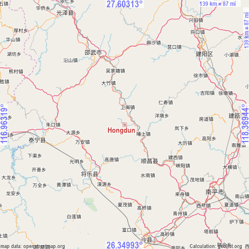
Hongdun GPS coordinates[2]
26° 58' 41.772" North, 117° 39' 58.716" East
| Map corner | latitude | longitude |
|---|---|---|
| Upper-left | 27.60313°, | 116.96319° |
| Center: | 26.97827°, | 117.66631° |
| Lower-right: | 26.34993°, | 118.36944° |
| Map W x H: | 139.3×139.3 km | = 86.6×86.6mi |
| max Lat: | 53.31946° ⇑78.7% North |
| Hongdun: | 26.97827° |
| min Lat: | ⇓21.3% South 18.22056° |
| min Long | Hongdun | max Long |
| 75.07348° | 117.66631° | 134.28917° |
| W 69.4%⇐ | ⇒30.6% E |
Elevation
Elevation of Hongdun is 156 m = 512 ft, and this is 328.8 m = 1079 ft below average elevation for this country.
| Max E: |
5622 m = 18445 ft | 51% |
| Avg. | 484.8 m = 1591 ft | |
| Hongdun | 156 m = 512 ft | |
Min E: |
-3 m = -10 ft | 49% |
See also: China elevation on elevation.city.
Geographical zone
Hongdun is located in North temperate zone (between Tropic of Cancer and the Arctic Circle). Distance of this Northern Tropic circle is 393.8 km =244.7 mi to South.| Distance of | km | miles | from Hongdun |
|---|---|---|---|
| North Pole | 7007.4 | 4354.2 | to North |
| Arctic Circle | 4401.5 | 2735 | to North |
| Tropic Cancer | 393.8 | 244.7 | to South |
| Equator | 2999.7 | 1863.9 | to South |


Nearby cities:
15 places around Hongdun: (largest is in red/bold)
• Anren
23.3 km =14.5 mi,  267°
267°
• Dagan
8.4 km =5.2 mi,  128°
128°
• Dayuan
29.3 km =18.2 mi,  261°
261°
• Gaotang
21 km =13 mi,  202°
202°
• Guyong
33.8 km =21 mi,  215°
215°
• Jianxi
33.6 km =20.9 mi,  122°
122°
• Jihui
27 km =16.8 mi, 121°
• Lanxia
31.7 km =19.7 mi,  93°
93°
• Pushang
11.4 km =7.1 mi, 115°
• Shuinan
31 km =19.3 mi,  155°
155°
• Wan’an
25.6 km =15.9 mi,  249°
249°
• Yangdun
21.3 km =13.2 mi,  75°
75°
• Yangkou
30.4 km =18.9 mi, 130°
• Yuankeng
24.5 km =15.2 mi,  169°
169°
• Zhengfang
29.7 km =18.5 mi, 172°
Sources, notices
• [Note1] Compared only with cities in China existing in our database
• [Src1] Map data: © OpenStreetMap contributors (CC-BY-SA)
• [Src2] Other city data from geonames.org with taken over terms of usage.
• [Src3] Geographical zone / Annual Mean Temperature by Robert A. Rohde @ Wikipedia
