Yangcun geodata
Yangcun (Tianjin) is a populated place; located in China in Asia/Shanghai (GMT+8) time zone. With population of 63,756 people, there are 678 cities with bigger population in this country. Compared to other cities in China, 84.2% of cities are located further ↓South; 66.3% of cities are located further ←West and 94.3% of cities have higher elevation than Yangcun. Note1


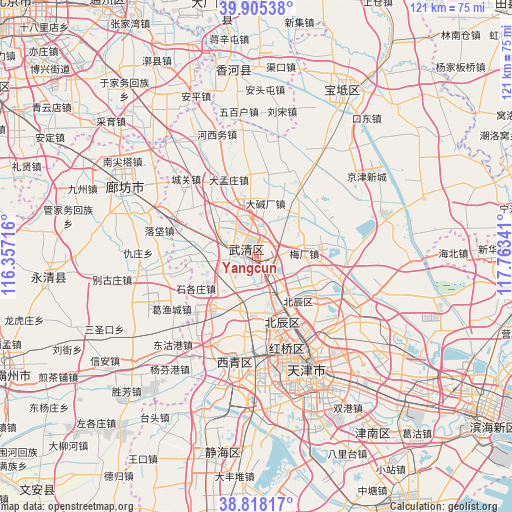
Yangcun GPS coordinates[2]
39° 21' 50.004" North, 117° 3' 37.008" East
| Map corner | latitude | longitude |
|---|---|---|
| Upper-left | 39.90538°, | 116.35716° |
| Center: | 39.36389°, | 117.06028° |
| Lower-right: | 38.81817°, | 117.76341° |
| Map W x H: | 120.9×120.9 km | = 75.1×75.1mi |
| max Lat: | 53.31946° ⇑15.8% North |
| Yangcun: | 39.36389° |
| min Lat: | ⇓84.2% South 18.22056° |
| min Long | Yangcun | max Long |
| 75.07348° | 117.06028° | 134.28917° |
| W 66.3%⇐ | ⇒33.7% E |
Elevation
Elevation of Yangcun is 7 m = 23 ft, and this is 477.8 m = 1568 ft below average elevation for this country.
| Max E: |
5622 m = 18445 ft | 94.3% |
| Avg. | 484.8 m = 1591 ft | |
| Yangcun | 7 m = 23 ft | |
Min E: |
-3 m = -10 ft | 5.7% |
See also: Yangcun elevation on elevation.city.
Geographical zone
Yangcun is located in North temperate zone (between Tropic of Cancer and the Arctic Circle). Distance of this Northern Tropic circle is 1770.9 km =1100.4 mi to South.| Distance of | km | miles | from Yangcun |
|---|---|---|---|
| North Pole | 5630.2 | 3498.4 | to North |
| Arctic Circle | 3024.3 | 1879.2 | to North |
| Tropic Cancer | 1770.9 | 1100.4 | to South |
| Equator | 4376.9 | 2719.7 | to South |


Nearby cities:
15 places around Yangcun: (largest is in red/bold)
• Beicaicun
14 km =8.7 mi,  347°
347°
• Beicang
15.2 km =9.4 mi,  159°
159°
• Chabaihu
13.6 km =8.5 mi,  33°
33°
• Changtun
8.9 km =5.5 mi,  5°
5°
• Chenzui
10.8 km =6.7 mi,  216°
216°
• Dadunqiu
5.2 km =3.2 mi,  333°
333°
• Dajianchang
12.8 km =8 mi, 8°
• Hangou
8.5 km =5.3 mi, 162°
• Huangzhuang
2.4 km =1.5 mi,  190°
190°
• Huangzhuang
5.5 km =3.4 mi, 186°
• Meichang
10.3 km =6.4 mi,  88°
88°
• Nancaicun
13 km =8.1 mi,  342°
342°
• Shimianzhuang
9.8 km =6.1 mi,  59°
59°
• Shuangjie
11.9 km =7.4 mi, 164°
• Shuangkou
14.2 km =8.8 mi, 192°
Sources, notices
• [Note1] Compared only with cities in China existing in our database
• [Src1] Map data: © OpenStreetMap contributors (CC-BY-SA)
• [Src2] Other city data from geonames.org with taken over terms of usage.
• [Src3] Geographical zone / Annual Mean Temperature by Robert A. Rohde @ Wikipedia
