Shuangkou geodata
Shuangkou (Tianjin) is a seat of a fourth-order administrative division; located in China in Asia/Shanghai (GMT+8) time zone. In our database, there are 1268 cities with bigger population. Compared to other cities in China, 83.9% of cities are located further ↓South; 66.1% of cities are located further ←West and 87.7% of cities have higher elevation than Shuangkou. Note1


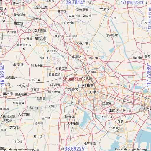
Shuangkou GPS coordinates[2]
39° 14' 20.184" North, 117° 1' 32.736" East
| Map corner | latitude | longitude |
|---|---|---|
| Upper-left | 39.7814°, | 116.32264° |
| Center: | 39.23894°, | 117.02576° |
| Lower-right: | 38.69225°, | 117.72889° |
| Map W x H: | 121.1×121.1 km | = 75.2×75.2mi |
| max Lat: | 53.31946° ⇑16.1% North |
| Shuangkou: | 39.23894° |
| min Lat: | ⇓83.9% South 18.22056° |
| min Long | Shuangkou | max Long |
| 75.07348° | 117.02576° | 134.28917° |
| W 66.1%⇐ | ⇒33.9% E |
Elevation
Elevation of Shuangkou is 12 m = 39 ft, and this is 472.8 m = 1551 ft below average elevation for this country.
| Max E: |
5622 m = 18445 ft | 87.7% |
| Avg. | 484.8 m = 1591 ft | |
| Shuangkou | 12 m = 39 ft | |
Min E: |
-3 m = -10 ft | 12.3% |
See also: China elevation on elevation.city.
Geographical zone
Shuangkou is located in North temperate zone (between Tropic of Cancer and the Arctic Circle). Distance of this Northern Tropic circle is 1757 km =1091.7 mi to South.| Distance of | km | miles | from Shuangkou |
|---|---|---|---|
| North Pole | 5644.1 | 3507.1 | to North |
| Arctic Circle | 3038.2 | 1887.8 | to North |
| Tropic Cancer | 1757 | 1091.7 | to South |
| Equator | 4363 | 2711 | to South |


Nearby cities:
15 places around Shuangkou: (largest is in red/bold)
• Beicang
8.3 km =5.2 mi,  92°
92°
• Chagugang
7.3 km =4.5 mi,  276°
276°
• Chenzui
6.2 km =3.9 mi,  326°
326°
• Guoyuan Xincun
9.2 km =5.7 mi,  101°
101°
• Hangou
8 km =5 mi,  43°
43°
• Hanjiashu
7 km =4.3 mi,  144°
144°
• Huangzhuang
8.8 km =5.5 mi,  15°
15°
• Huangzhuang
11.8 km =7.3 mi,  12°
12°
• Mazhuang
9.8 km =6.1 mi,  109°
109°
• Nancang
10.3 km =6.4 mi, 112°
• Qingguang
4.5 km =2.8 mi,  171°
171°
• Shuangjie
6.6 km =4.1 mi,  68°
68°
• Wangqinzhuang
5.6 km =3.5 mi, 100°
• Xianyang Beilu
11.6 km =7.2 mi,  121°
121°
• Yangliuqing
11.5 km =7.1 mi,  191°
191°
Sources, notices
• [Note1] Compared only with cities in China existing in our database
• [Src1] Map data: © OpenStreetMap contributors (CC-BY-SA)
• [Src2] Other city data from geonames.org with taken over terms of usage.
• [Src3] Geographical zone / Annual Mean Temperature by Robert A. Rohde @ Wikipedia
