Yajiang geodata
Yajiang (Chongqing) is a seat of a fourth-order administrative division; located in China in Asia/Shanghai (GMT+8) time zone. In our database, there are 1268 cities with bigger population. Compared to other cities in China, 60.3% of cities are located further ↑North; 82.6% of cities are located further →East and 56.4% of cities have lower elevation than Yajiang. Note1


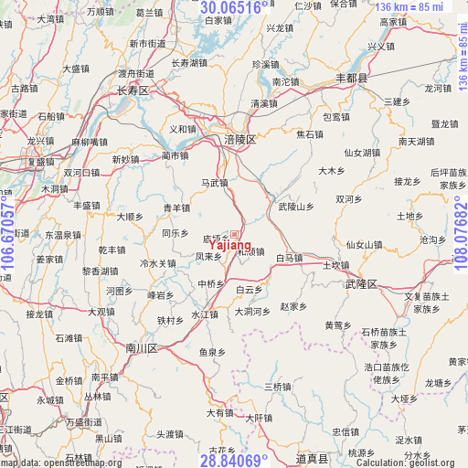
Yajiang GPS coordinates[2]
29° 27' 17.172" North, 107° 22' 25.284" East
| Map corner | latitude | longitude |
|---|---|---|
| Upper-left | 30.06516°, | 106.67057° |
| Center: | 29.45477°, | 107.37369° |
| Lower-right: | 28.84069°, | 108.07682° |
| Map W x H: | 136.1×136.1 km | = 84.6×84.6mi |
| max Lat: | 53.31946° ⇑60.3% North |
| Yajiang: | 29.45477° |
| min Lat: | ⇓39.7% South 18.22056° |
| min Long | Yajiang | max Long |
| 75.07348° | 107.37369° | 134.28917° |
| W 17.4%⇐ | ⇒82.6% E |
Elevation
Elevation of Yajiang is 220 m = 722 ft, and this is 264.8 m = 869 ft below average elevation for this country.
| Max E: |
5622 m = 18445 ft | 43.6% |
| Avg. | 484.8 m = 1591 ft | |
| Yajiang | 220 m = 722 ft | |
Min E: |
-3 m = -10 ft | 56.4% |
See also: China elevation on elevation.city.
Geographical zone
Yajiang is located in North temperate zone (between Tropic of Cancer and the Arctic Circle). Distance of this Northern Tropic circle is 669.1 km =415.8 mi to South.| Distance of | km | miles | from Yajiang |
|---|---|---|---|
| North Pole | 6732 | 4183.1 | to North |
| Arctic Circle | 4126.1 | 2563.8 | to North |
| Tropic Cancer | 669.1 | 415.8 | to South |
| Equator | 3275.1 | 2035.1 | to South |


Nearby cities:
15 places around Yajiang: (largest is in red/bold)
• Baima
16.6 km =10.3 mi,  110°
110°
• Baitao
15.3 km =9.5 mi,  45°
45°
• Baiyun
16.3 km =10.1 mi,  164°
164°
• Changba
16.6 km =10.3 mi,  143°
143°
• Fenglai
9.7 km =6 mi,  230°
230°
• Heshun
6.8 km =4.2 mi,  134°
134°
• Jubao
16.7 km =10.4 mi,  252°
252°
• Mawu
16.4 km =10.2 mi,  339°
339°
• Miaoya
5.3 km =3.3 mi,  259°
259°
• Pingqiao
9.7 km =6 mi,  201°
201°
• Qilong
18.5 km =11.5 mi, 233°
• Taihe
9.6 km =6 mi,  323°
323°
• Tongle
17.1 km =10.6 mi,  272°
272°
• Zhongqiao
15.6 km =9.7 mi,  205°
205°
• Zili
12.4 km =7.7 mi,  358°
358°
Sources, notices
• [Note1] Compared only with cities in China existing in our database
• [Src1] Map data: © OpenStreetMap contributors (CC-BY-SA)
• [Src2] Other city data from geonames.org with taken over terms of usage.
• [Src3] Geographical zone / Annual Mean Temperature by Robert A. Rohde @ Wikipedia
