Changba geodata
Changba (Chongqing) is a seat of a fourth-order administrative division; located in China in Asia/Shanghai (GMT+8) time zone. In our database, there are 1268 cities with bigger population. Compared to other cities in China, 61.6% of cities are located further ↑North; 82.3% of cities are located further →East and 60.3% of cities have lower elevation than Changba. Note1


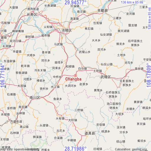
Changba GPS coordinates[2]
29° 20' 4.776" North, 107° 28' 29.856" East
| Map corner | latitude | longitude |
|---|---|---|
| Upper-left | 29.94577°, | 106.77184° |
| Center: | 29.33466°, | 107.47496° |
| Lower-right: | 28.71986°, | 108.17809° |
| Map W x H: | 136.3×136.3 km | = 84.7×84.7mi |
| max Lat: | 53.31946° ⇑61.6% North |
| Changba: | 29.33466° |
| min Lat: | ⇓38.4% South 18.22056° |
| min Long | Changba | max Long |
| 75.07348° | 107.47496° | 134.28917° |
| W 17.7%⇐ | ⇒82.3% E |
Elevation
Elevation of Changba is 263 m = 863 ft, and this is 221.8 m = 728 ft below average elevation for this country.
| Max E: |
5622 m = 18445 ft | 39.7% |
| Avg. | 484.8 m = 1591 ft | |
| Changba | 263 m = 863 ft | |
Min E: |
-3 m = -10 ft | 60.3% |
See also: China elevation on elevation.city.
Geographical zone
Changba is located in North temperate zone (between Tropic of Cancer and the Arctic Circle). Distance of this Northern Tropic circle is 655.8 km =407.5 mi to South.| Distance of | km | miles | from Changba |
|---|---|---|---|
| North Pole | 6745.4 | 4191.4 | to North |
| Arctic Circle | 4139.5 | 2572.2 | to North |
| Tropic Cancer | 655.8 | 407.5 | to South |
| Equator | 3261.7 | 2026.7 | to South |


Nearby cities:
15 places around Changba: (largest is in red/bold)
• Baima
9.6 km =6 mi,  37°
37°
• Baitao
24.1 km =15 mi,  2°
2°
• Baiyun
6 km =3.7 mi,  246°
246°
• Fenglai
18.7 km =11.6 mi,  292°
292°
• Heshun
10 km =6.2 mi,  329°
329°
• Huangying
24.4 km =15.2 mi,  123°
123°
• Miaoya
19.5 km =12.1 mi,  309°
309°
• Pingqiao
14 km =8.7 mi, 288°
• Shuijiang
20.9 km =13 mi,  242°
242°
• Tiekuang
11.1 km =6.9 mi,  198°
198°
• Wulongshan
23.3 km =14.5 mi,  20°
20°
• Yajiang
16.6 km =10.3 mi,  323°
323°
• Yangjiao
14.6 km =9.1 mi,  61°
61°
• Zhaojia
10.5 km =6.5 mi,  136°
136°
• Zhongqiao
16.6 km =10.3 mi,  267°
267°
Sources, notices
• [Note1] Compared only with cities in China existing in our database
• [Src1] Map data: © OpenStreetMap contributors (CC-BY-SA)
• [Src2] Other city data from geonames.org with taken over terms of usage.
• [Src3] Geographical zone / Annual Mean Temperature by Robert A. Rohde @ Wikipedia
