Xitianwei geodata
Xitianwei (Fujian) is a seat of a fourth-order administrative division; located in China in Asia/Shanghai (GMT+8) time zone. In our database, there are 1268 cities with bigger population. Compared to other cities in China, 84.3% of cities are located further ↑North; 76.3% of cities are located further ←West and 89.9% of cities have higher elevation than Xitianwei. Note1


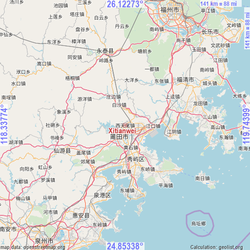
Xitianwei GPS coordinates[2]
25° 29' 23.028" North, 119° 2' 27.096" East
| Map corner | latitude | longitude |
|---|---|---|
| Upper-left | 26.12273°, | 118.33774° |
| Center: | 25.48973°, | 119.04086° |
| Lower-right: | 24.85338°, | 119.74399° |
| Map W x H: | 141.1×141.1 km | = 87.7×87.7mi |
| max Lat: | 53.31946° ⇑84.3% North |
| Xitianwei: | 25.48973° |
| min Lat: | ⇓15.7% South 18.22056° |
| min Long | Xitianwei | max Long |
| 75.07348° | 119.04086° | 134.28917° |
| W 76.3%⇐ | ⇒23.7% E |
Elevation
Elevation of Xitianwei is 10 m = 33 ft, and this is 474.8 m = 1558 ft below average elevation for this country.
| Max E: |
5622 m = 18445 ft | 89.9% |
| Avg. | 484.8 m = 1591 ft | |
| Xitianwei | 10 m = 33 ft | |
Min E: |
-3 m = -10 ft | 10.1% |
See also: China elevation on elevation.city.
Geographical zone
Xitianwei is located in North temperate zone (between Tropic of Cancer and the Arctic Circle). Distance of this Northern Tropic circle is 228.3 km =141.9 mi to South.| Distance of | km | miles | from Xitianwei |
|---|---|---|---|
| North Pole | 7172.9 | 4457 | to North |
| Arctic Circle | 4567 | 2837.8 | to North |
| Tropic Cancer | 228.3 | 141.9 | to South |
| Equator | 2834.2 | 1761.1 | to South |


Nearby cities:
15 places around Xitianwei: (largest is in red/bold)
• Baisha
12.1 km =7.5 mi,  345°
345°
• Baitang
7 km =4.3 mi,  128°
128°
• Changtai
11 km =6.8 mi,  274°
274°
• Chengnan
7.3 km =4.5 mi,  203°
203°
• Chengxiao
5.6 km =3.5 mi, 202°
• Guohuan
7.1 km =4.4 mi,  101°
101°
• Huangshi
12.8 km =8 mi,  165°
165°
• Jiangkou
15.8 km =9.8 mi,  91°
91°
• Putian
6.4 km =4 mi,  208°
208°
• Qiulu
6.3 km =3.9 mi,  49°
49°
• Sanjiangkou
9.1 km =5.7 mi,  124°
124°
• Wutang
3.8 km =2.4 mi,  82°
82°
• Xindu
10.1 km =6.3 mi,  181°
181°
• Xinxian
18.6 km =11.6 mi,  3°
3°
• Zhuangbian
17.4 km =10.8 mi,  338°
338°
Sources, notices
• [Note1] Compared only with cities in China existing in our database
• [Src1] Map data: © OpenStreetMap contributors (CC-BY-SA)
• [Src2] Other city data from geonames.org with taken over terms of usage.
• [Src3] Geographical zone / Annual Mean Temperature by Robert A. Rohde @ Wikipedia
