Jiangkou geodata
Jiangkou (Fujian) is a seat of a fourth-order administrative division; located in China in Asia/Shanghai (GMT+8) time zone. With population of 59,902 people, there are 734 cities with bigger population in this country. Compared to other cities in China, 84.3% of cities are located further ↑North; 77% of cities are located further ←West and 89.9% of cities have higher elevation than Jiangkou. Note1


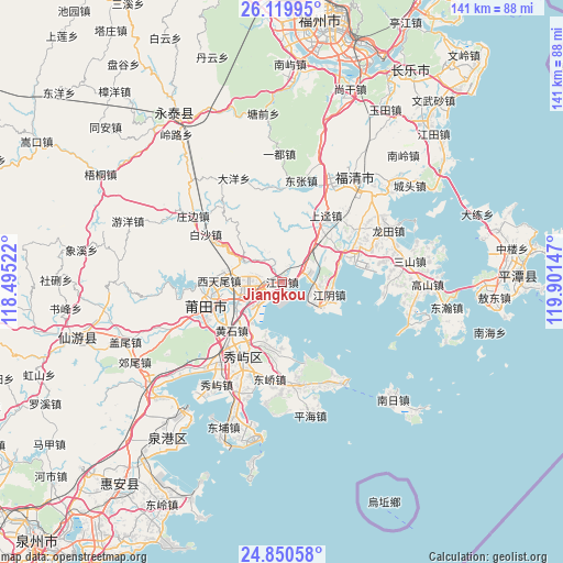
Jiangkou GPS coordinates[2]
25° 29' 12.984" North, 119° 11' 54.024" East
| Map corner | latitude | longitude |
|---|---|---|
| Upper-left | 26.11995°, | 118.49522° |
| Center: | 25.48694°, | 119.19834° |
| Lower-right: | 24.85058°, | 119.90147° |
| Map W x H: | 141.1×141.1 km | = 87.7×87.7mi |
| max Lat: | 53.31946° ⇑84.3% North |
| Jiangkou: | 25.48694° |
| min Lat: | ⇓15.7% South 18.22056° |
| min Long | Jiangkou | max Long |
| 75.07348° | 119.19834° | 134.28917° |
| W 77%⇐ | ⇒23% E |
Elevation
Elevation of Jiangkou is 10 m = 33 ft, and this is 474.8 m = 1558 ft below average elevation for this country.
| Max E: |
5622 m = 18445 ft | 89.9% |
| Avg. | 484.8 m = 1591 ft | |
| Jiangkou | 10 m = 33 ft | |
Min E: |
-3 m = -10 ft | 10.1% |
See also: Jiangkou elevation on elevation.city.
Geographical zone
Jiangkou is located in North temperate zone (between Tropic of Cancer and the Arctic Circle). Distance of this Northern Tropic circle is 228 km =141.7 mi to South.| Distance of | km | miles | from Jiangkou |
|---|---|---|---|
| North Pole | 7173.2 | 4457.2 | to North |
| Arctic Circle | 4567.3 | 2838 | to North |
| Tropic Cancer | 228 | 141.7 | to South |
| Equator | 2833.9 | 1760.9 | to South |


Nearby cities:
15 places around Jiangkou: (largest is in red/bold)
• Baitang
11.1 km =6.9 mi,  248°
248°
• Beigao
17.5 km =10.9 mi,  200°
200°
• Chengnan
19.8 km =12.3 mi, 251°
• Chengxiao
18.6 km =11.6 mi, 254°
• Guohuan
8.9 km =5.5 mi,  262°
262°
• Huangshi
17.5 km =10.9 mi,  226°
226°
• Jiangyin
12.2 km =7.6 mi,  104°
104°
• Putian
19.6 km =12.2 mi, 254°
• Qiulu
11.8 km =7.3 mi,  291°
291°
• Sanjiangkou
9.6 km =6 mi,  239°
239°
• Wutang
12.1 km =7.5 mi,  273°
273°
• Xincuo
6.1 km =3.8 mi,  60°
60°
• Xindu
18.8 km =11.7 mi, 238°
• Xitianwei
15.8 km =9.8 mi, 271°
• Yuxi
16 km =9.9 mi,  35°
35°
Sources, notices
• [Note1] Compared only with cities in China existing in our database
• [Src1] Map data: © OpenStreetMap contributors (CC-BY-SA)
• [Src2] Other city data from geonames.org with taken over terms of usage.
• [Src3] Geographical zone / Annual Mean Temperature by Robert A. Rohde @ Wikipedia
