Xinyu geodata
Xinyu (Jiangxi) is a seat of a second-order administrative division; located in China in Asia/Shanghai (GMT+8) time zone. With population of 97,480 people, there are 437 cities with bigger population in this country. Compared to other cities in China, 75.2% of cities are located further ↑North; 53.9% of cities are located further ←West and 66.1% of cities have higher elevation than Xinyu. Note1


Xinyu GPS coordinates[2]
27° 48' 15.444" North, 114° 56' 0.06" East
| Map corner | latitude | longitude |
|---|---|---|
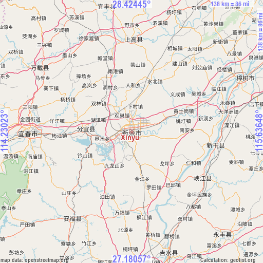
| Upper-left | 28.42445°, | 114.23023° |
| Center: | 27.80429°, | 114.93335° |
| Lower-right: | 27.18057°, | 115.63648° |
| Map W x H: | 138.3×138.3 km | = 85.9×85.9mi |
| max Lat: | 53.31946° ⇑75.2% North |
| Xinyu: | 27.80429° |
| min Lat: | ⇓24.8% South 18.22056° |
| min Long | Xinyu | max Long |
| 75.07348° | 114.93335° | 134.28917° |
| W 53.9%⇐ | ⇒46.1% E |
Elevation
Elevation of Xinyu is 68 m = 223 ft, and this is 416.8 m = 1367 ft below average elevation for this country.
| Max E: |
5622 m = 18445 ft | 66.1% |
| Avg. | 484.8 m = 1591 ft | |
| Xinyu | 68 m = 223 ft | |
Min E: |
-3 m = -10 ft | 33.9% |
See also: Xinyu elevation on elevation.city.
Geographical zone
Xinyu is located in North temperate zone (between Tropic of Cancer and the Arctic Circle). Distance of this Northern Tropic circle is 485.6 km =301.7 mi to South.| Distance of | km | miles | from Xinyu |
|---|---|---|---|
| North Pole | 6915.5 | 4297.1 | to North |
| Arctic Circle | 4309.6 | 2677.9 | to North |
| Tropic Cancer | 485.6 | 301.7 | to South |
| Equator | 3091.5 | 1921 | to South |


Nearby cities:
15 places around Xinyu: (largest is in red/bold)
• Dongbian
19.2 km =11.9 mi,  99°
99°
• Guanchao
11.3 km =7 mi,  323°
323°
• Hexia
8.4 km =5.2 mi,  261°
261°
• Huze
19.2 km =11.9 mi,  290°
290°
• Jieshui
17.2 km =10.7 mi, 262°
• Jiulongshan
20 km =12.4 mi,  207°
207°
• Liangshan
14.9 km =9.3 mi,  190°
190°
• Luofang
18.5 km =11.5 mi,  72°
72°
• Mahong
15.2 km =9.4 mi,  32°
32°
• Ouli
16.8 km =10.4 mi, 324°
• Shuixi
9.7 km =6 mi,  77°
77°
• Xiacun
13.3 km =8.3 mi,  6°
6°
• Xinyu
9.4 km =5.8 mi, 294°
• Yanxi
20.8 km =12.9 mi,  149°
149°
• Zhushan
3.1 km =1.9 mi,  162°
162°
Sources, notices
• [Note1] Compared only with cities in China existing in our database
• [Src1] Map data: © OpenStreetMap contributors (CC-BY-SA)
• [Src2] Other city data from geonames.org with taken over terms of usage.
• [Src3] Geographical zone / Annual Mean Temperature by Robert A. Rohde @ Wikipedia
