Xinxu geodata
Xinxu (Fujian) is a seat of a fourth-order administrative division; located in China in Asia/Shanghai (GMT+8) time zone. In our database, there are 1268 cities with bigger population. Compared to other cities in China, 87.5% of cities are located further ↑North; 71.7% of cities are located further ←West and 74.8% of cities have higher elevation than Xinxu. Note1


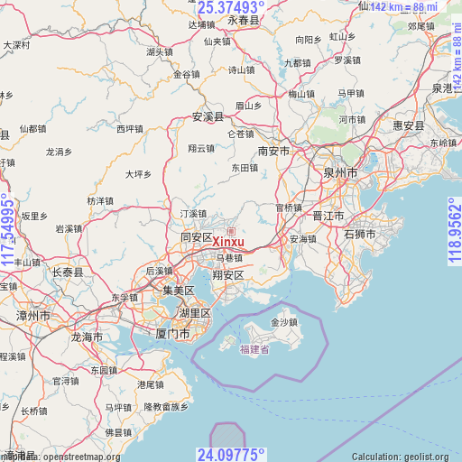
Xinxu GPS coordinates[2]
24° 44' 16.728" North, 118° 15' 11.052" East
| Map corner | latitude | longitude |
|---|---|---|
| Upper-left | 25.37493°, | 117.54995° |
| Center: | 24.73798°, | 118.25307° |
| Lower-right: | 24.09775°, | 118.9562° |
| Map W x H: | 142×142 km | = 88.2×88.2mi |
| max Lat: | 53.31946° ⇑87.5% North |
| Xinxu: | 24.73798° |
| min Lat: | ⇓12.5% South 18.22056° |
| min Long | Xinxu | max Long |
| 75.07348° | 118.25307° | 134.28917° |
| W 71.7%⇐ | ⇒28.3% E |
Elevation
Elevation of Xinxu is 37 m = 121 ft, and this is 447.8 m = 1469 ft below average elevation for this country.
| Max E: |
5622 m = 18445 ft | 74.8% |
| Avg. | 484.8 m = 1591 ft | |
| Xinxu | 37 m = 121 ft | |
Min E: |
-3 m = -10 ft | 25.2% |
See also: China elevation on elevation.city.
Geographical zone
Xinxu is located in North temperate zone (between Tropic of Cancer and the Arctic Circle). Distance of this Northern Tropic circle is 144.7 km =89.9 mi to South.| Distance of | km | miles | from Xinxu |
|---|---|---|---|
| North Pole | 7256.5 | 4509 | to North |
| Arctic Circle | 4650.6 | 2889.7 | to North |
| Tropic Cancer | 144.7 | 89.9 | to South |
| Equator | 2750.6 | 1709.1 | to South |


Nearby cities:
15 places around Xinxu: (largest is in red/bold)
• Anhai
22.1 km =13.7 mi,  95°
95°
• Aotoucun
22 km =13.7 mi,  186°
186°
• Datong
11.1 km =6.9 mi,  268°
268°
• Dongshi
22.1 km =13.7 mi,  111°
111°
• Hongtang
6.4 km =4 mi,  245°
245°
• Lianhecun
18.7 km =11.6 mi,  152°
152°
• Liuwudiancun
19.8 km =12.3 mi,  198°
198°
• Maxiang
7.9 km =4.9 mi, 185°
• Neikeng
21.6 km =13.4 mi,  75°
75°
• Shijing
21.7 km =13.5 mi,  127°
127°
• Wuxian
9.3 km =5.8 mi, 273°
• Xike
12.6 km =7.8 mi,  235°
235°
• Xindian
14.3 km =8.9 mi, 185°
• Xinmin
12.6 km =7.8 mi,  258°
258°
• Yingcun
21.3 km =13.2 mi,  224°
224°
Sources, notices
• [Note1] Compared only with cities in China existing in our database
• [Src1] Map data: © OpenStreetMap contributors (CC-BY-SA)
• [Src2] Other city data from geonames.org with taken over terms of usage.
• [Src3] Geographical zone / Annual Mean Temperature by Robert A. Rohde @ Wikipedia
