Lianhecun geodata
Lianhecun (Fujian) is a populated place; located in China in Asia/Shanghai (GMT+8) time zone. With population of 2,130 people, there are 1021 cities with bigger population in this country. Compared to other cities in China, 88.2% of cities are located further ↑North; 72.2% of cities are located further ←West and 99.7% of cities have higher elevation than Lianhecun. Note1


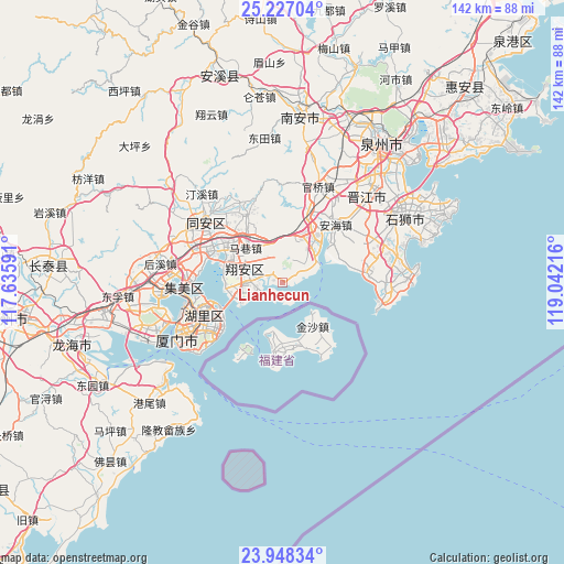
Lianhecun GPS coordinates[2]
24° 35' 21.552" North, 118° 20' 20.508" East
| Map corner | latitude | longitude |
|---|---|---|
| Upper-left | 25.22704°, | 117.63591° |
| Center: | 24.58932°, | 118.33903° |
| Lower-right: | 23.94834°, | 119.04216° |
| Map W x H: | 142.2×142.2 km | = 88.4×88.4mi |
| max Lat: | 53.31946° ⇑88.2% North |
| Lianhecun: | 24.58932° |
| min Lat: | ⇓11.8% South 18.22056° |
| min Long | Lianhecun | max Long |
| 75.07348° | 118.33903° | 134.28917° |
| W 72.2%⇐ | ⇒27.8% E |
Elevation
Elevation of Lianhecun is 1 m = 3 ft, and this is 483.8 m = 1587 ft below average elevation for this country.
| Max E: |
5622 m = 18445 ft | 99.7% |
| Avg. | 484.8 m = 1591 ft | |
| Lianhecun | 1 m = 3 ft | |
Min E: |
-3 m = -10 ft | 0.3% |
See also: China elevation on elevation.city.
Geographical zone
Lianhecun is located in North temperate zone (between Tropic of Cancer and the Arctic Circle). Distance of this Northern Tropic circle is 128.2 km =79.7 mi to South.| Distance of | km | miles | from Lianhecun |
|---|---|---|---|
| North Pole | 7273 | 4519.2 | to North |
| Arctic Circle | 4667.1 | 2900 | to North |
| Tropic Cancer | 128.2 | 79.7 | to South |
| Equator | 2734.1 | 1698.9 | to South |


Nearby cities:
15 places around Lianhecun: (largest is in red/bold)
• Anhai
19.7 km =12.2 mi,  42°
42°
• Aotoucun
12.4 km =7.7 mi,  244°
244°
• Dadeng
5.2 km =3.2 mi,  192°
192°
• Dongshi
14.5 km =9 mi,  54°
54°
• Hongtang
20.1 km =12.5 mi,  313°
313°
• Liuwudiancun
15.2 km =9.4 mi,  261°
261°
• Maping
24.2 km =15 mi,  63°
63°
• Maxiang
12.8 km =8 mi, 312°
• Shijing
9.3 km =5.8 mi,  68°
68°
• Tatou
19.2 km =11.9 mi,  80°
80°
• Wubao
21.7 km =13.5 mi,  88°
88°
• Xike
21.3 km =13.2 mi,  296°
296°
• Xindian
10.2 km =6.3 mi,  283°
283°
• Xinxu
18.7 km =11.6 mi,  332°
332°
• Yingcun
23.8 km =14.8 mi,  273°
273°
Sources, notices
• [Note1] Compared only with cities in China existing in our database
• [Src1] Map data: © OpenStreetMap contributors (CC-BY-SA)
• [Src2] Other city data from geonames.org with taken over terms of usage.
• [Src3] Geographical zone / Annual Mean Temperature by Robert A. Rohde @ Wikipedia
