Xinxu geodata
Xinxu (Guangdong) is a seat of a fourth-order administrative division; located in China in Asia/Shanghai (GMT+8) time zone. In our database, there are 1268 cities with bigger population. Compared to other cities in China, 95.1% of cities are located further ↑North; 50.5% of cities are located further ←West and 68.4% of cities have higher elevation than Xinxu. Note1


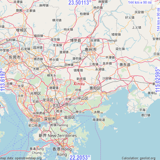
Xinxu GPS coordinates[2]
22° 51' 17.136" North, 114° 19' 22.152" East
| Map corner | latitude | longitude |
|---|---|---|
| Upper-left | 23.50113°, | 113.6197° |
| Center: | 22.85476°, | 114.32282° |
| Lower-right: | 22.2053°, | 115.02595° |
| Map W x H: | 144.1×144.1 km | = 89.5×89.5mi |
| max Lat: | 53.31946° ⇑95.1% North |
| Xinxu: | 22.85476° |
| min Lat: | ⇓4.9% South 18.22056° |
| min Long | Xinxu | max Long |
| 75.07348° | 114.32282° | 134.28917° |
| W 50.5%⇐ | ⇒49.5% E |
Elevation
Elevation of Xinxu is 58 m = 190 ft, and this is 426.8 m = 1400 ft below average elevation for this country.
| Max E: |
5622 m = 18445 ft | 68.4% |
| Avg. | 484.8 m = 1591 ft | |
| Xinxu | 58 m = 190 ft | |
Min E: |
-3 m = -10 ft | 31.6% |
See also: China elevation on elevation.city.
Geographical zone
Xinxu is located in North Torrid zone (between Equator and Tropic of Cancer). Distance of this Northern Tropic circle is 64.7 km =40.2 mi to North.| Distance of | km | miles | from Xinxu |
|---|---|---|---|
| North Pole | 7465.9 | 4639.1 | to North |
| Arctic Circle | 4860 | 3019.9 | to North |
| Tropic Cancer | 64.7 | 40.2 | to North |
| Equator | 2541.2 | 1579 | to South |


Nearby cities:
15 places around Xinxu: (largest is in red/bold)
• Chenjiang
19.5 km =12.1 mi,  354°
354°
• Danshui
16.1 km =10 mi,  112°
112°
• Huihuan
20.3 km =12.6 mi,  12°
12°
• Kengzi
12.4 km =7.7 mi,  156°
156°
• Lilin
19 km =11.8 mi,  324°
324°
• Longcheng
20.2 km =12.6 mi,  213°
213°
• Longgang
15.9 km =9.9 mi,  202°
202°
• Pingdi
9.6 km =6 mi,  192°
192°
• Pingshan
17.9 km =11.1 mi,  176°
176°
• Qingxi
16.3 km =10.1 mi,  263°
263°
• Qiuchang
11 km =6.8 mi, 110°
• Sandong
20.3 km =12.6 mi,  39°
39°
• Tongqiao
18.4 km =11.4 mi,  4°
4°
• Yonghu
19.9 km =12.4 mi,  57°
57°
• Zhenlong
9.6 km =6 mi, 350°
Sources, notices
• [Note1] Compared only with cities in China existing in our database
• [Src1] Map data: © OpenStreetMap contributors (CC-BY-SA)
• [Src2] Other city data from geonames.org with taken over terms of usage.
• [Src3] Geographical zone / Annual Mean Temperature by Robert A. Rohde @ Wikipedia
