Pingdi geodata
Pingdi (Guangdong) is a seat of a fourth-order administrative division; located in China in Asia/Shanghai (GMT+8) time zone. In our database, there are 1268 cities with bigger population. Compared to other cities in China, 95.4% of cities are located further ↑North; 50.4% of cities are located further ←West and 77.7% of cities have higher elevation than Pingdi. Note1


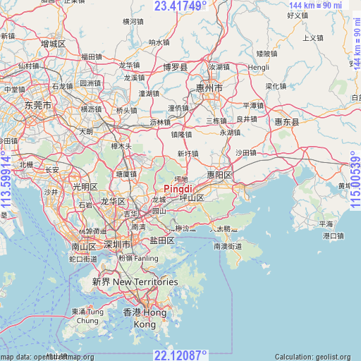
Pingdi GPS coordinates[2]
22° 46' 14.592" North, 114° 18' 8.136" East
| Map corner | latitude | longitude |
|---|---|---|
| Upper-left | 23.41749°, | 113.59914° |
| Center: | 22.77072°, | 114.30226° |
| Lower-right: | 22.12087°, | 115.00539° |
| Map W x H: | 144.2×144.2 km | = 89.6×89.6mi |
| max Lat: | 53.31946° ⇑95.4% North |
| Pingdi: | 22.77072° |
| min Lat: | ⇓4.6% South 18.22056° |
| min Long | Pingdi | max Long |
| 75.07348° | 114.30226° | 134.28917° |
| W 50.4%⇐ | ⇒49.6% E |
Elevation
Elevation of Pingdi is 31 m = 102 ft, and this is 453.8 m = 1489 ft below average elevation for this country.
| Max E: |
5622 m = 18445 ft | 77.7% |
| Avg. | 484.8 m = 1591 ft | |
| Pingdi | 31 m = 102 ft | |
Min E: |
-3 m = -10 ft | 22.3% |
See also: China elevation on elevation.city.
Geographical zone
Pingdi is located in North Torrid zone (between Equator and Tropic of Cancer). Distance of this Northern Tropic circle is 74.1 km =46 mi to North.| Distance of | km | miles | from Pingdi |
|---|---|---|---|
| North Pole | 7475.2 | 4644.9 | to North |
| Arctic Circle | 4869.3 | 3025.6 | to North |
| Tropic Cancer | 74.1 | 46 | to North |
| Equator | 2531.9 | 1573.2 | to South |


Nearby cities:
15 places around Pingdi: (largest is in red/bold)
• Danshui
17.2 km =10.7 mi,  79°
79°
• Fenggang
15.8 km =9.8 mi,  264°
264°
• Henggang
17.4 km =10.8 mi,  218°
218°
• Kengzi
7.3 km =4.5 mi,  106°
106°
• Kuiyong
18.8 km =11.7 mi,  141°
141°
• Longcheng
11.7 km =7.3 mi,  229°
229°
• Longgang
6.7 km =4.2 mi, 216°
• Meisha
19.2 km =11.9 mi,  180°
180°
• Pinghu
21 km =13 mi,  244°
244°
• Pingshan
9.2 km =5.7 mi,  158°
158°
• Qingxi
15.9 km =9.9 mi,  297°
297°
• Qiuchang
13.6 km =8.5 mi,  65°
65°
• Tangxia
21.5 km =13.4 mi,  281°
281°
• Xinxu
9.6 km =6 mi,  12°
12°
• Zhenlong
18.9 km =11.7 mi,  1°
1°
Sources, notices
• [Note1] Compared only with cities in China existing in our database
• [Src1] Map data: © OpenStreetMap contributors (CC-BY-SA)
• [Src2] Other city data from geonames.org with taken over terms of usage.
• [Src3] Geographical zone / Annual Mean Temperature by Robert A. Rohde @ Wikipedia
