Xinhua geodata
Xinhua (Guangdong) is a seat of a fourth-order administrative division; located in China in Asia/Shanghai (GMT+8) time zone. In our database, there are 1268 cities with bigger population. Compared to other cities in China, 92.7% of cities are located further ↑North; 56.3% of cities are located further →East and 86.9% of cities have higher elevation than Xinhua. Note1


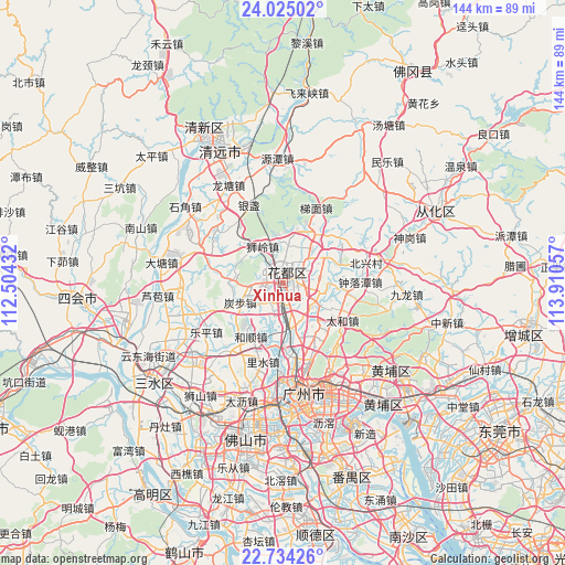
Xinhua GPS coordinates[2]
23° 22' 52.356" North, 113° 12' 26.784" East
| Map corner | latitude | longitude |
|---|---|---|
| Upper-left | 24.02502°, | 112.50432° |
| Center: | 23.38121°, | 113.20744° |
| Lower-right: | 22.73426°, | 113.91057° |
| Map W x H: | 143.5×143.5 km | = 89.2×89.2mi |
| max Lat: | 53.31946° ⇑92.7% North |
| Xinhua: | 23.38121° |
| min Lat: | ⇓7.3% South 18.22056° |
| min Long | Xinhua | max Long |
| 75.07348° | 113.20744° | 134.28917° |
| W 43.7%⇐ | ⇒56.3% E |
Elevation
Elevation of Xinhua is 13 m = 43 ft, and this is 471.8 m = 1548 ft below average elevation for this country.
| Max E: |
5622 m = 18445 ft | 86.9% |
| Avg. | 484.8 m = 1591 ft | |
| Xinhua | 13 m = 43 ft | |
Min E: |
-3 m = -10 ft | 13.1% |
See also: China elevation on elevation.city.
Geographical zone
Xinhua is located in North Torrid zone (between Equator and Tropic of Cancer). Distance of this Northern Tropic circle is 6.2 km =3.9 mi to North.| Distance of | km | miles | from Xinhua |
|---|---|---|---|
| North Pole | 7407.3 | 4602.7 | to North |
| Arctic Circle | 4801.4 | 2983.5 | to North |
| Tropic Cancer | 6.2 | 3.9 | to North |
| Equator | 2599.7 | 1615.4 | to South |


Nearby cities:
15 places around Xinhua: (largest is in red/bold)
• Huadong
13.3 km =8.3 mi,  62°
62°
• Huangshi
19.9 km =12.4 mi,  163°
163°
• Huashan
9.8 km =6.1 mi,  38°
38°
• Jiahe
18.1 km =11.2 mi, 159°
• Jianggao
12.9 km =8 mi,  169°
169°
• Junhe
14.4 km =8.9 mi, 160°
• Renhe
10.2 km =6.3 mi,  121°
121°
• Shijing
19.5 km =12.1 mi, 172°
• Shiling
10.1 km =6.3 mi,  325°
325°
• Taihe
17.6 km =10.9 mi, 124°
• Tanbu
11.9 km =7.4 mi,  245°
245°
• Timian
20.4 km =12.7 mi,  23°
23°
• Yayao
2 km =1.2 mi, 156°
• Yongping
19 km =11.8 mi,  149°
149°
• Zhongluotan
19 km =11.8 mi,  88°
88°
Sources, notices
• [Note1] Compared only with cities in China existing in our database
• [Src1] Map data: © OpenStreetMap contributors (CC-BY-SA)
• [Src2] Other city data from geonames.org with taken over terms of usage.
• [Src3] Geographical zone / Annual Mean Temperature by Robert A. Rohde @ Wikipedia
