Taihe geodata
Taihe (Guangdong) is a seat of a fourth-order administrative division; located in China in Asia/Shanghai (GMT+8) time zone. In our database, there are 1268 cities with bigger population. Compared to other cities in China, 93% of cities are located further ↑North; 55.3% of cities are located further →East and 82.9% of cities have higher elevation than Taihe. Note1


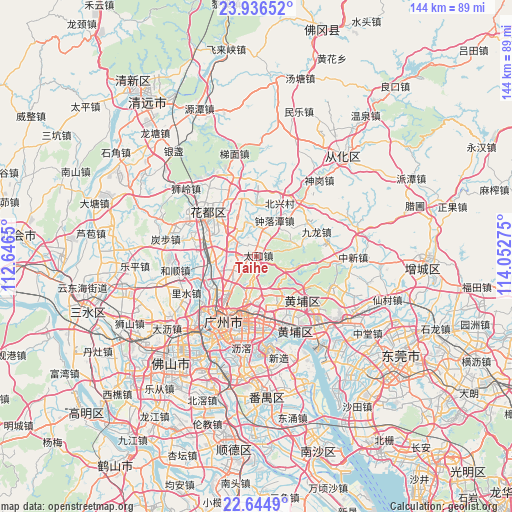
Taihe GPS coordinates[2]
23° 17' 32.208" North, 113° 20' 58.632" East
| Map corner | latitude | longitude |
|---|---|---|
| Upper-left | 23.93652°, | 112.6465° |
| Center: | 23.29228°, | 113.34962° |
| Lower-right: | 22.6449°, | 114.05275° |
| Map W x H: | 143.6×143.6 km | = 89.2×89.2mi |
| max Lat: | 53.31946° ⇑93% North |
| Taihe: | 23.29228° |
| min Lat: | ⇓7% South 18.22056° |
| min Long | Taihe | max Long |
| 75.07348° | 113.34962° | 134.28917° |
| W 44.7%⇐ | ⇒55.3% E |
Elevation
Elevation of Taihe is 20 m = 66 ft, and this is 464.8 m = 1525 ft below average elevation for this country.
| Max E: |
5622 m = 18445 ft | 82.9% |
| Avg. | 484.8 m = 1591 ft | |
| Taihe | 20 m = 66 ft | |
Min E: |
-3 m = -10 ft | 17.1% |
See also: China elevation on elevation.city.
Geographical zone
Taihe is located in North Torrid zone (between Equator and Tropic of Cancer). Distance of this Northern Tropic circle is 16.1 km =10 mi to North.| Distance of | km | miles | from Taihe |
|---|---|---|---|
| North Pole | 7417.2 | 4608.8 | to North |
| Arctic Circle | 4811.3 | 2989.6 | to North |
| Tropic Cancer | 16.1 | 10 | to North |
| Equator | 2589.9 | 1609.3 | to South |


Nearby cities:
15 places around Taihe: (largest is in red/bold)
• Changxing
12.7 km =7.9 mi,  181°
181°
• Huangshi
12.7 km =7.9 mi,  223°
223°
• Jiahe
10.8 km =6.7 mi,  228°
228°
• Jianggao
12.5 km =7.8 mi,  257°
257°
• Junhe
10.4 km =6.5 mi,  249°
249°
• Lianhe
10.3 km =6.4 mi,  144°
144°
• Longdong
10.5 km =6.5 mi,  167°
167°
• Renhe
7.4 km =4.6 mi,  307°
307°
• Shijing
15.4 km =9.6 mi, 232°
• Tonghe
10.6 km =6.6 mi,  198°
198°
• Wushan
14.8 km =9.2 mi, 181°
• Xinshi
14.1 km =8.8 mi, 224°
• Xintang
15.6 km =9.7 mi,  157°
157°
• Yongping
8.2 km =5.1 mi, 217°
• Zhongluotan
11.2 km =7 mi,  23°
23°
Sources, notices
• [Note1] Compared only with cities in China existing in our database
• [Src1] Map data: © OpenStreetMap contributors (CC-BY-SA)
• [Src2] Other city data from geonames.org with taken over terms of usage.
• [Src3] Geographical zone / Annual Mean Temperature by Robert A. Rohde @ Wikipedia
