Xiashan geodata
Xiashan (Guangdong) is a seat of a fourth-order administrative division; located in China in Asia/Shanghai (GMT+8) time zone. In our database, there are 1268 cities with bigger population. Compared to other cities in China, 93.3% of cities are located further ↑North; 62.6% of cities are located further ←West and 92.7% of cities have higher elevation than Xiashan. Note1


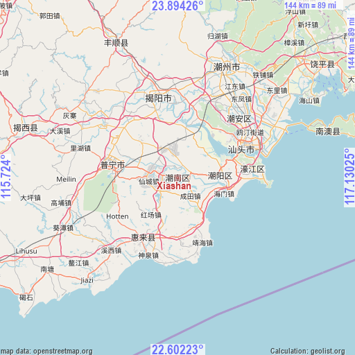
Xiashan GPS coordinates[2]
23° 14' 59.316" North, 116° 25' 37.632" East
| Map corner | latitude | longitude |
|---|---|---|
| Upper-left | 23.89426°, | 115.724° |
| Center: | 23.24981°, | 116.42712° |
| Lower-right: | 22.60223°, | 117.13025° |
| Map W x H: | 143.7×143.7 km | = 89.3×89.3mi |
| max Lat: | 53.31946° ⇑93.3% North |
| Xiashan: | 23.24981° |
| min Lat: | ⇓6.7% South 18.22056° |
| min Long | Xiashan | max Long |
| 75.07348° | 116.42712° | 134.28917° |
| W 62.6%⇐ | ⇒37.4% E |
Elevation
Elevation of Xiashan is 8 m = 26 ft, and this is 476.8 m = 1564 ft below average elevation for this country.
| Max E: |
5622 m = 18445 ft | 92.7% |
| Avg. | 484.8 m = 1591 ft | |
| Xiashan | 8 m = 26 ft | |
Min E: |
-3 m = -10 ft | 7.3% |
See also: China elevation on elevation.city.
Geographical zone
Xiashan is located in North Torrid zone (between Equator and Tropic of Cancer). Distance of this Northern Tropic circle is 20.8 km =12.9 mi to North.| Distance of | km | miles | from Xiashan |
|---|---|---|---|
| North Pole | 7421.9 | 4611.8 | to North |
| Arctic Circle | 4816 | 2992.5 | to North |
| Tropic Cancer | 20.8 | 12.9 | to North |
| Equator | 2585.1 | 1606.3 | to South |


Nearby cities:
15 places around Xiashan: (largest is in red/bold)
• Chendian
11.6 km =7.2 mi,  284°
284°
• Chengtian
8.5 km =5.3 mi,  146°
146°
• Guiyu
11.8 km =7.3 mi,  313°
313°
• Gurao
10.9 km =6.8 mi,  351°
351°
• Heping
5.1 km =3.2 mi,  85°
85°
• Hexi
14.8 km =9.2 mi,  55°
55°
• Jingdu
14.2 km =8.8 mi,  117°
117°
• Jinpu
12.3 km =7.6 mi, 89°
• Liangying
8 km =5 mi,  244°
244°
• Longtian
11.7 km =7.3 mi,  139°
139°
• Lugang
4.4 km =2.7 mi,  129°
129°
• Nanjing
16.6 km =10.3 mi, 307°
• Simapu
6.8 km =4.2 mi, 281°
• Tongyu
4.2 km =2.6 mi, 352°
• Xiancheng
11.3 km =7 mi,  262°
262°
Sources, notices
• [Note1] Compared only with cities in China existing in our database
• [Src1] Map data: © OpenStreetMap contributors (CC-BY-SA)
• [Src2] Other city data from geonames.org with taken over terms of usage.
• [Src3] Geographical zone / Annual Mean Temperature by Robert A. Rohde @ Wikipedia
