Liangying geodata
Liangying (Guangdong) is a seat of a fourth-order administrative division; located in China in Asia/Shanghai (GMT+8) time zone. In our database, there are 1268 cities with bigger population. Compared to other cities in China, 93.4% of cities are located further ↑North; 62.2% of cities are located further ←West and 86.9% of cities have higher elevation than Liangying. Note1


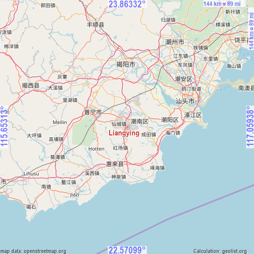
Liangying GPS coordinates[2]
23° 13' 7.392" North, 116° 21' 22.5" East
| Map corner | latitude | longitude |
|---|---|---|
| Upper-left | 23.86332°, | 115.65313° |
| Center: | 23.21872°, | 116.35625° |
| Lower-right: | 22.57099°, | 117.05938° |
| Map W x H: | 143.7×143.7 km | = 89.3×89.3mi |
| max Lat: | 53.31946° ⇑93.4% North |
| Liangying: | 23.21872° |
| min Lat: | ⇓6.6% South 18.22056° |
| min Long | Liangying | max Long |
| 75.07348° | 116.35625° | 134.28917° |
| W 62.2%⇐ | ⇒37.8% E |
Elevation
Elevation of Liangying is 13 m = 43 ft, and this is 471.8 m = 1548 ft below average elevation for this country.
| Max E: |
5622 m = 18445 ft | 86.9% |
| Avg. | 484.8 m = 1591 ft | |
| Liangying | 13 m = 43 ft | |
Min E: |
-3 m = -10 ft | 13.1% |
See also: China elevation on elevation.city.
Geographical zone
Liangying is located in North Torrid zone (between Equator and Tropic of Cancer). Distance of this Northern Tropic circle is 24.2 km =15 mi to North.| Distance of | km | miles | from Liangying |
|---|---|---|---|
| North Pole | 7425.4 | 4613.9 | to North |
| Arctic Circle | 4819.5 | 2994.7 | to North |
| Tropic Cancer | 24.2 | 15 | to North |
| Equator | 2581.7 | 1604.2 | to South |


Nearby cities:
15 places around Liangying: (largest is in red/bold)
• Chendian
7.5 km =4.7 mi,  327°
327°
• Chengtian
12.4 km =7.7 mi,  106°
106°
• Guiyu
11.6 km =7.2 mi,  353°
353°
• Heping
12.9 km =8 mi,  72°
72°
• Hongchang
12 km =7.5 mi,  202°
202°
• Junbu
10.9 km =6.8 mi,  292°
292°
• Leiling
14.9 km =9.3 mi,  175°
175°
• Lugang
10.6 km =6.6 mi,  86°
86°
• Nanjing
14.8 km =9.2 mi,  335°
335°
• Simapu
4.8 km =3 mi,  6°
6°
• Tongyu
10.1 km =6.3 mi,  41°
41°
• Xiajiashan
11.2 km =7 mi, 285°
• Xiancheng
4.5 km =2.8 mi,  297°
297°
• Xiashan
8 km =5 mi,  64°
64°
• Zhanlong
12 km =7.5 mi,  310°
310°
Sources, notices
• [Note1] Compared only with cities in China existing in our database
• [Src1] Map data: © OpenStreetMap contributors (CC-BY-SA)
• [Src2] Other city data from geonames.org with taken over terms of usage.
• [Src3] Geographical zone / Annual Mean Temperature by Robert A. Rohde @ Wikipedia
