Xianxiang geodata
Xianxiang (Zhejiang) is a seat of a fourth-order administrative division; located in China in Asia/Shanghai (GMT+8) time zone. In our database, there are 1268 cities with bigger population. Compared to other cities in China, 57.6% of cities are located further ↑North; 90.8% of cities are located further ←West and 95.9% of cities have higher elevation than Xianxiang. Note1


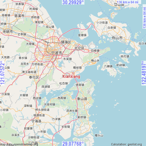
Xianxiang GPS coordinates[2]
29° 41' 25.224" North, 121° 46' 43.824" East
| Map corner | latitude | longitude |
|---|---|---|
| Upper-left | 30.29929°, | 121.07572° |
| Center: | 29.69034°, | 121.77884° |
| Lower-right: | 29.07768°, | 122.48197° |
| Map W x H: | 135.8×135.8 km | = 84.4×84.4mi |
| max Lat: | 53.31946° ⇑57.6% North |
| Xianxiang: | 29.69034° |
| min Lat: | ⇓42.4% South 18.22056° |
| min Long | Xianxiang | max Long |
| 75.07348° | 121.77884° | 134.28917° |
| W 90.8%⇐ | ⇒9.2% E |
Elevation
Elevation of Xianxiang is 6 m = 20 ft, and this is 478.8 m = 1571 ft below average elevation for this country.
| Max E: |
5622 m = 18445 ft | 95.9% |
| Avg. | 484.8 m = 1591 ft | |
| Xianxiang | 6 m = 20 ft | |
Min E: |
-3 m = -10 ft | 4.1% |
See also: China elevation on elevation.city.
Geographical zone
Xianxiang is located in North temperate zone (between Tropic of Cancer and the Arctic Circle). Distance of this Northern Tropic circle is 695.3 km =432 mi to South.| Distance of | km | miles | from Xianxiang |
|---|---|---|---|
| North Pole | 6705.8 | 4166.8 | to North |
| Arctic Circle | 4099.9 | 2547.6 | to North |
| Tropic Cancer | 695.3 | 432 | to South |
| Equator | 3301.3 | 2051.3 | to South |


Nearby cities:
15 places around Xianxiang: (largest is in red/bold)
• Daqi
22.5 km =14 mi,  4°
4°
• Daxu
20.2 km =12.6 mi,  151°
151°
• Dongqianhu
18.1 km =11.2 mi,  308°
308°
• Dongwu
14.3 km =8.9 mi,  337°
337°
• Hengxizhen
18.6 km =11.6 mi,  282°
282°
• Li’ao
23.6 km =14.7 mi,  59°
59°
• Qiucun
18 km =11.2 mi,  237°
237°
• Qiu’ai
22.9 km =14.2 mi,  321°
321°
• Song’ao
12.5 km =7.8 mi,  225°
225°
• Tangtou
6.7 km =4.2 mi,  250°
250°
• Tuci
21 km =13 mi,  134°
134°
• Wuxiang
19.4 km =12.1 mi,  332°
332°
• Xianxiang
13 km =8.1 mi, 151°
• Xiaying
22.1 km =13.7 mi, 305°
• Yunlong
20.3 km =12.6 mi,  297°
297°
Sources, notices
• [Note1] Compared only with cities in China existing in our database
• [Src1] Map data: © OpenStreetMap contributors (CC-BY-SA)
• [Src2] Other city data from geonames.org with taken over terms of usage.
• [Src3] Geographical zone / Annual Mean Temperature by Robert A. Rohde @ Wikipedia
