Xiangyang geodata
Xiangyang (Jiangsu) is a seat of a fourth-order administrative division; located in China in Asia/Shanghai (GMT+8) time zone. In our database, there are 1268 cities with bigger population. Compared to other cities in China, 60.5% of cities are located further ↓South; 90.8% of cities are located further ←West and 98.3% of cities have higher elevation than Xiangyang. Note1


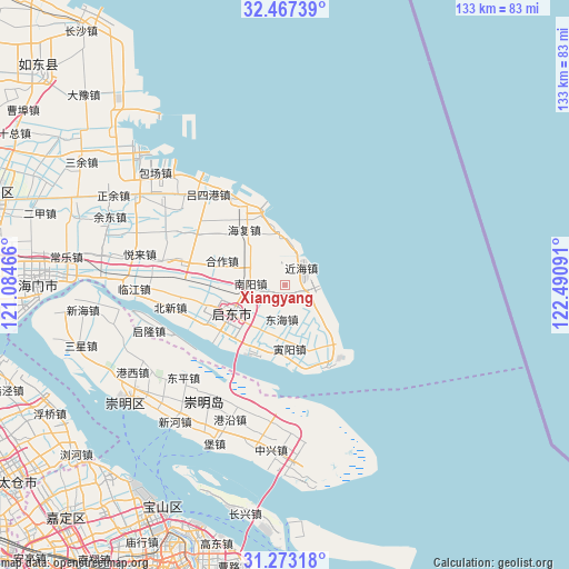
Xiangyang GPS coordinates[2]
31° 52' 19.992" North, 121° 47' 16.008" East
| Map corner | latitude | longitude |
|---|---|---|
| Upper-left | 32.46739°, | 121.08466° |
| Center: | 31.87222°, | 121.78778° |
| Lower-right: | 31.27318°, | 122.49091° |
| Map W x H: | 132.8×132.8 km | = 82.5×82.5mi |
| max Lat: | 53.31946° ⇑39.5% North |
| Xiangyang: | 31.87222° |
| min Lat: | ⇓60.5% South 18.22056° |
| min Long | Xiangyang | max Long |
| 75.07348° | 121.78778° | 134.28917° |
| W 90.8%⇐ | ⇒9.2% E |
Elevation
Elevation of Xiangyang is 4 m = 13 ft, and this is 480.8 m = 1577 ft below average elevation for this country.
| Max E: |
5622 m = 18445 ft | 98.3% |
| Avg. | 484.8 m = 1591 ft | |
| Xiangyang | 4 m = 13 ft | |
Min E: |
-3 m = -10 ft | 1.7% |
See also: China elevation on elevation.city.
Geographical zone
Xiangyang is located in North temperate zone (between Tropic of Cancer and the Arctic Circle). Distance of this Northern Tropic circle is 937.9 km =582.8 mi to South.| Distance of | km | miles | from Xiangyang |
|---|---|---|---|
| North Pole | 6463.2 | 4016 | to North |
| Arctic Circle | 3857.3 | 2396.8 | to North |
| Tropic Cancer | 937.9 | 582.8 | to South |
| Equator | 3543.9 | 2202.1 | to South |


Nearby cities:
15 places around Xiangyang: (largest is in red/bold)
• Caojia
15.5 km =9.6 mi,  291°
291°
• Daxing
16.7 km =10.4 mi,  219°
219°
• Donghai
13.9 km =8.6 mi,  145°
145°
• Dongyuan
13.2 km =8.2 mi,  334°
334°
• Gaojia
19.9 km =12.4 mi,  255°
255°
• Haifu
15.9 km =9.9 mi,  323°
323°
• Hehe
15 km =9.3 mi,  174°
174°
• Huifeng
17.5 km =10.9 mi,  236°
236°
• Huilong
14.3 km =8.9 mi, 241°
• Huiping
12.1 km =7.5 mi,  184°
184°
• Jinhai
5.1 km =3.2 mi,  350°
350°
• Nanyang
7.5 km =4.7 mi,  271°
271°
• Rixinhe
11.6 km =7.2 mi,  298°
298°
• Xin’an
8.3 km =5.2 mi, 184°
• Yinyang
18.8 km =11.7 mi,  158°
158°
Sources, notices
• [Note1] Compared only with cities in China existing in our database
• [Src1] Map data: © OpenStreetMap contributors (CC-BY-SA)
• [Src2] Other city data from geonames.org with taken over terms of usage.
• [Src3] Geographical zone / Annual Mean Temperature by Robert A. Rohde @ Wikipedia
