Donghai geodata
Donghai (Jiangsu) is a seat of a fourth-order administrative division; located in China in Asia/Shanghai (GMT+8) time zone. In our database, there are 1268 cities with bigger population. Compared to other cities in China, 59.9% of cities are located further ↓South; 91% of cities are located further ←West and 98.9% of cities have higher elevation than Donghai. Note1


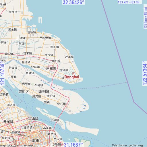
Donghai GPS coordinates[2]
31° 46' 6.276" North, 121° 52' 13.836" East
| Map corner | latitude | longitude |
|---|---|---|
| Upper-left | 32.36426°, | 121.16739° |
| Center: | 31.76841°, | 121.87051° |
| Lower-right: | 31.1687°, | 122.57364° |
| Map W x H: | 132.9×132.9 km | = 82.6×82.6mi |
| max Lat: | 53.31946° ⇑40.1% North |
| Donghai: | 31.76841° |
| min Lat: | ⇓59.9% South 18.22056° |
| min Long | Donghai | max Long |
| 75.07348° | 121.87051° | 134.28917° |
| W 91%⇐ | ⇒9% E |
Elevation
Elevation of Donghai is 3 m = 10 ft, and this is 481.8 m = 1581 ft below average elevation for this country.
| Max E: |
5622 m = 18445 ft | 98.9% |
| Avg. | 484.8 m = 1591 ft | |
| Donghai | 3 m = 10 ft | |
Min E: |
-3 m = -10 ft | 1.1% |
See also: China elevation on elevation.city.
Geographical zone
Donghai is located in North temperate zone (between Tropic of Cancer and the Arctic Circle). Distance of this Northern Tropic circle is 926.4 km =575.6 mi to South.| Distance of | km | miles | from Donghai |
|---|---|---|---|
| North Pole | 6474.7 | 4023.2 | to North |
| Arctic Circle | 3868.9 | 2404 | to North |
| Tropic Cancer | 926.4 | 575.6 | to South |
| Equator | 3532.3 | 2194.9 | to South |


Nearby cities:
15 places around Donghai: (largest is in red/bold)
• Caojia
28.2 km =17.5 mi,  307°
307°
• Daxing
18.4 km =11.4 mi,  265°
265°
• Dongyuan
27.1 km =16.8 mi,  330°
330°
• Gaojia
27.8 km =17.3 mi,  283°
283°
• Haifu
29.8 km =18.5 mi,  324°
324°
• Hehe
7.2 km =4.5 mi,  242°
242°
• Huifeng
22.5 km =14 mi, 274°
• Huilong
20.9 km =13 mi, 283°
• Huiping
8.8 km =5.5 mi, 266°
• Jinhai
18.7 km =11.6 mi, 332°
• Nanyang
19.3 km =12 mi, 307°
• Rixinhe
24.9 km =15.5 mi, 313°
• Xiangyang
13.9 km =8.6 mi, 325°
• Xin’an
9.1 km =5.7 mi,  291°
291°
• Yinyang
6 km =3.7 mi,  187°
187°
Sources, notices
• [Note1] Compared only with cities in China existing in our database
• [Src1] Map data: © OpenStreetMap contributors (CC-BY-SA)
• [Src2] Other city data from geonames.org with taken over terms of usage.
• [Src3] Geographical zone / Annual Mean Temperature by Robert A. Rohde @ Wikipedia
