Wutong geodata
Wutong (Fujian) is a seat of a fourth-order administrative division; located in China in Asia/Shanghai (GMT+8) time zone. In our database, there are 1268 cities with bigger population. Compared to other cities in China, 83.4% of cities are located further ↑North; 74.6% of cities are located further ←West and 58.4% of cities have higher elevation than Wutong. Note1


Wutong GPS coordinates[2]
25° 43' 44.472" North, 118° 44' 34.908" East
| Map corner | latitude | longitude |
|---|---|---|
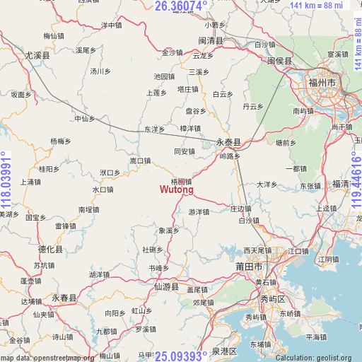
| Upper-left | 26.36074°, | 118.03991° |
| Center: | 25.72902°, | 118.74303° |
| Lower-right: | 25.09393°, | 119.44616° |
| Map W x H: | 140.9×140.9 km | = 87.6×87.6mi |
| max Lat: | 53.31946° ⇑83.4% North |
| Wutong: | 25.72902° |
| min Lat: | ⇓16.6% South 18.22056° |
| min Long | Wutong | max Long |
| 75.07348° | 118.74303° | 134.28917° |
| W 74.6%⇐ | ⇒25.4% E |
Elevation
Elevation of Wutong is 109 m = 358 ft, and this is 375.8 m = 1233 ft below average elevation for this country.
| Max E: |
5622 m = 18445 ft | 58.4% |
| Avg. | 484.8 m = 1591 ft | |
| Wutong | 109 m = 358 ft | |
Min E: |
-3 m = -10 ft | 41.6% |
See also: China elevation on elevation.city.
Geographical zone
Wutong is located in North temperate zone (between Tropic of Cancer and the Arctic Circle). Distance of this Northern Tropic circle is 254.9 km =158.4 mi to South.| Distance of | km | miles | from Wutong |
|---|---|---|---|
| North Pole | 7146.3 | 4440.5 | to North |
| Arctic Circle | 4540.4 | 2821.3 | to North |
| Tropic Cancer | 254.9 | 158.4 | to South |
| Equator | 2860.8 | 1777.6 | to South |


Nearby cities:
15 places around Wutong: (largest is in red/bold)
• Changqing
23.8 km =14.8 mi,  316°
316°
• Chengfeng
24.6 km =15.3 mi,  50°
50°
• Chixi
12.6 km =7.8 mi,  62°
62°
• Dongyang
22.9 km =14.2 mi,  333°
333°
• Fuquan
18.7 km =11.6 mi, 48°
• Linglu
21.4 km =13.3 mi, 61°
• Shicang
14.1 km =8.8 mi,  176°
176°
• Songkou
17.9 km =11.1 mi,  297°
297°
• Tong’an
11.6 km =7.2 mi,  6°
6°
• Xiaba
22.8 km =14.2 mi,  346°
346°
• Xiangxi
19.4 km =12.1 mi,  193°
193°
• Youyang
13.2 km =8.2 mi,  150°
150°
• Zhangcheng
23.4 km =14.5 mi, 56°
• Zhangyang
21.2 km =13.2 mi, 9°
• Zhongshan
22.4 km =13.9 mi,  167°
167°
Sources, notices
• [Note1] Compared only with cities in China existing in our database
• [Src1] Map data: © OpenStreetMap contributors (CC-BY-SA)
• [Src2] Other city data from geonames.org with taken over terms of usage.
• [Src3] Geographical zone / Annual Mean Temperature by Robert A. Rohde @ Wikipedia
