Wenquan geodata
Wenquan (Chongqing) is a seat of a fourth-order administrative division; located in China in Asia/Shanghai (GMT+8) time zone. In our database, there are 1268 cities with bigger population. Compared to other cities in China, 57.5% of cities are located further ↓South; 78.5% of cities are located further →East and 61.5% of cities have lower elevation than Wenquan. Note1


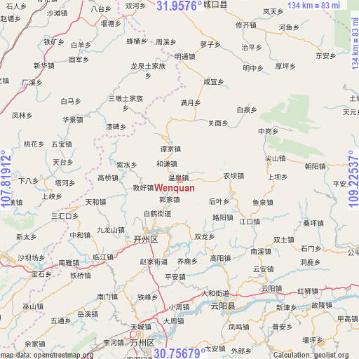
Wenquan GPS coordinates[2]
31° 21' 32.796" North, 108° 31' 20.064" East
| Map corner | latitude | longitude |
|---|---|---|
| Upper-left | 31.9576°, | 107.81912° |
| Center: | 31.35911°, | 108.52224° |
| Lower-right: | 30.75679°, | 109.22537° |
| Map W x H: | 133.5×133.5 km | = 83×83mi |
| max Lat: | 53.31946° ⇑42.5% North |
| Wenquan: | 31.35911° |
| min Lat: | ⇓57.5% South 18.22056° |
| min Long | Wenquan | max Long |
| 75.07348° | 108.52224° | 134.28917° |
| W 21.5%⇐ | ⇒78.5% E |
Elevation
Elevation of Wenquan is 277 m = 909 ft, and this is 207.8 m = 682 ft below average elevation for this country.
| Max E: |
5622 m = 18445 ft | 38.5% |
| Avg. | 484.8 m = 1591 ft | |
| Wenquan | 277 m = 909 ft | |
Min E: |
-3 m = -10 ft | 61.5% |
See also: China elevation on elevation.city.
Geographical zone
Wenquan is located in North temperate zone (between Tropic of Cancer and the Arctic Circle). Distance of this Northern Tropic circle is 880.9 km =547.4 mi to South.| Distance of | km | miles | from Wenquan |
|---|---|---|---|
| North Pole | 6520.3 | 4051.5 | to North |
| Arctic Circle | 3914.4 | 2432.3 | to North |
| Tropic Cancer | 880.9 | 547.4 | to South |
| Equator | 3486.8 | 2166.6 | to South |


Nearby cities:
15 places around Wenquan: (largest is in red/bold)
• Baihe
12 km =7.5 mi,  207°
207°
• Baiqiao
10.9 km =6.8 mi,  141°
141°
• Dajin
18.2 km =11.3 mi,  336°
336°
• Dunhao
15.8 km =9.8 mi,  259°
259°
• Fengle
21.4 km =13.3 mi, 208°
• Guojia
8.1 km =5 mi, 208°
• Heqian
8 km =5 mi,  321°
321°
• Heyan
14.1 km =8.8 mi,  91°
91°
• Houba
17.2 km =10.7 mi,  185°
185°
• Houye
16.6 km =10.3 mi,  117°
117°
• Jinfeng
18.8 km =11.7 mi,  168°
168°
• Luyang
21 km =13 mi,  130°
130°
• Nongba
20.7 km =12.9 mi,  84°
84°
• Tanjia
11 km =6.8 mi,  348°
348°
• Zishui
20.6 km =12.8 mi,  286°
286°
Sources, notices
• [Note1] Compared only with cities in China existing in our database
• [Src1] Map data: © OpenStreetMap contributors (CC-BY-SA)
• [Src2] Other city data from geonames.org with taken over terms of usage.
• [Src3] Geographical zone / Annual Mean Temperature by Robert A. Rohde @ Wikipedia
