Weiyuan geodata
Weiyuan (Shanxi) is a seat of a fourth-order administrative division; located in China in Asia/Shanghai (GMT+8) time zone. In our database, there are 1268 cities with bigger population. Compared to other cities in China, 86.2% of cities are located further ↓South; 60.9% of cities are located further →East and 89.7% of cities have lower elevation than Weiyuan. Note1


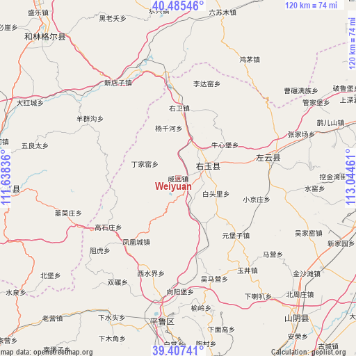
Weiyuan GPS coordinates[2]
39° 56' 54.816" North, 112° 20' 29.328" East
| Map corner | latitude | longitude |
|---|---|---|
| Upper-left | 40.48546°, | 111.63836° |
| Center: | 39.94856°, | 112.34148° |
| Lower-right: | 39.40741°, | 113.04461° |
| Map W x H: | 119.9×119.9 km | = 74.5×74.5mi |
| max Lat: | 53.31946° ⇑13.8% North |
| Weiyuan: | 39.94856° |
| min Lat: | ⇓86.2% South 18.22056° |
| min Long | Weiyuan | max Long |
| 75.07348° | 112.34148° | 134.28917° |
| W 39.1%⇐ | ⇒60.9% E |
Elevation
Elevation of Weiyuan is 1338 m = 4390 ft, and this is 853.2 m = 2799 ft above average elevation for this country.
| Max E: |
5622 m = 18445 ft | 10.3% |
| Weiyuan | 1338 m 4390 ft | |
| Avg. | 484.8 m = 1591 ft | |
Min E: |
-3 m = -10 ft | 89.7% |
See also: China elevation on elevation.city.
Geographical zone
Weiyuan is located in North temperate zone (between Tropic of Cancer and the Arctic Circle). Distance of this Northern Tropic circle is 1835.9 km =1140.8 mi to South.| Distance of | km | miles | from Weiyuan |
|---|---|---|---|
| North Pole | 5565.2 | 3458.1 | to North |
| Arctic Circle | 2959.3 | 1838.8 | to North |
| Tropic Cancer | 1835.9 | 1140.8 | to South |
| Equator | 4441.9 | 2760.1 | to South |


Nearby cities:
15 places around Weiyuan: (largest is in red/bold)
• Baitouli
13.7 km =8.5 mi,  111°
111°
• Dingjiayao
12.3 km =7.6 mi,  293°
293°
• Fenghuangcheng
25.5 km =15.8 mi,  213°
213°
• Gaojiabu
19.5 km =12.1 mi,  152°
152°
• Hougaoshizhuang
26.1 km =16.2 mi,  238°
238°
• Lidayao
33.5 km =20.8 mi,  16°
16°
• Niuxinbao
19.3 km =12 mi,  53°
53°
• Pendiqing
28.8 km =17.9 mi,  268°
268°
• Xiaojingzhuang
27.3 km =17 mi,  104°
104°
• Xincheng
11.1 km =6.9 mi,  67°
67°
• Xishuijie
33 km =20.5 mi,  196°
196°
• Yangqianhe
17.3 km =10.7 mi,  349°
349°
• Youwei
23.8 km =14.8 mi,  0°
0°
• Yuanbuzi
21.6 km =13.4 mi,  130°
130°
• Yunxing
30.9 km =19.2 mi,  79°
79°
Sources, notices
• [Note1] Compared only with cities in China existing in our database
• [Src1] Map data: © OpenStreetMap contributors (CC-BY-SA)
• [Src2] Other city data from geonames.org with taken over terms of usage.
• [Src3] Geographical zone / Annual Mean Temperature by Robert A. Rohde @ Wikipedia
