Wanxiang geodata
Wanxiang (Shanghai) is a seat of a fourth-order administrative division; located in China in Asia/Shanghai (GMT+8) time zone. In our database, there are 1268 cities with bigger population. Compared to other cities in China, 54.6% of cities are located further ↓South; 90.8% of cities are located further ←West and 94.3% of cities have higher elevation than Wanxiang. Note1


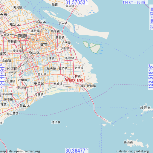
Wanxiang GPS coordinates[2]
30° 58' 10.38" North, 121° 48' 54.108" East
| Map corner | latitude | longitude |
|---|---|---|
| Upper-left | 31.57053°, | 121.11191° |
| Center: | 30.96955°, | 121.81503° |
| Lower-right: | 30.36477°, | 122.51816° |
| Map W x H: | 134.1×134.1 km | = 83.3×83.3mi |
| max Lat: | 53.31946° ⇑45.4% North |
| Wanxiang: | 30.96955° |
| min Lat: | ⇓54.6% South 18.22056° |
| min Long | Wanxiang | max Long |
| 75.07348° | 121.81503° | 134.28917° |
| W 90.8%⇐ | ⇒9.2% E |
Elevation
Elevation of Wanxiang is 7 m = 23 ft, and this is 477.8 m = 1568 ft below average elevation for this country.
| Max E: |
5622 m = 18445 ft | 94.3% |
| Avg. | 484.8 m = 1591 ft | |
| Wanxiang | 7 m = 23 ft | |
Min E: |
-3 m = -10 ft | 5.7% |
See also: China elevation on elevation.city.
Geographical zone
Wanxiang is located in North temperate zone (between Tropic of Cancer and the Arctic Circle). Distance of this Northern Tropic circle is 837.6 km =520.5 mi to South.| Distance of | km | miles | from Wanxiang |
|---|---|---|---|
| North Pole | 6563.6 | 4078.4 | to North |
| Arctic Circle | 3957.7 | 2459.2 | to North |
| Tropic Cancer | 837.6 | 520.5 | to South |
| Equator | 3443.5 | 2139.7 | to South |


Nearby cities:
15 places around Wanxiang: (largest is in red/bold)
• Datuan
7.8 km =4.8 mi,  273°
273°
• Fengcheng
17.7 km =11 mi,  250°
250°
• Huamu
37.2 km =23.1 mi,  316°
316°
• Jiangchuanlu
39.2 km =24.4 mi,  277°
277°
• Jinhui
30.8 km =19.1 mi, 274°
• Kangqiao
29.4 km =18.3 mi,  307°
307°
• Laogang
7.1 km =4.4 mi,  21°
21°
• Pingan
11.5 km =7.1 mi,  227°
227°
• Pujiang
33.4 km =20.8 mi,  294°
294°
• Qingcun
23 km =14.3 mi,  257°
257°
• Shaochang
9 km =5.6 mi,  220°
220°
• Shaochang Zhen
9 km =5.6 mi, 221°
• Shuyuan
6 km =3.7 mi,  134°
134°
• Shuyuan Zhen
6 km =3.7 mi, 134°
• Zhelin
36.3 km =22.6 mi, 245°
Sources, notices
• [Note1] Compared only with cities in China existing in our database
• [Src1] Map data: © OpenStreetMap contributors (CC-BY-SA)
• [Src2] Other city data from geonames.org with taken over terms of usage.
• [Src3] Geographical zone / Annual Mean Temperature by Robert A. Rohde @ Wikipedia
