Datuan geodata
Datuan (Shanghai) is a seat of a fourth-order administrative division; located in China in Asia/Shanghai (GMT+8) time zone. In our database, there are 1268 cities with bigger population. Compared to other cities in China, 54.6% of cities are located further ↓South; 90.7% of cities are located further ←West and 89.9% of cities have higher elevation than Datuan. Note1


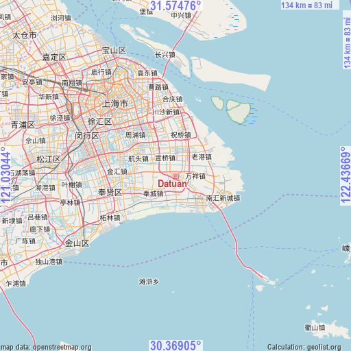
Datuan GPS coordinates[2]
30° 58' 25.716" North, 121° 44' 0.816" East
| Map corner | latitude | longitude |
|---|---|---|
| Upper-left | 31.57476°, | 121.03044° |
| Center: | 30.97381°, | 121.73356° |
| Lower-right: | 30.36905°, | 122.43669° |
| Map W x H: | 134.1×134.1 km | = 83.3×83.3mi |
| max Lat: | 53.31946° ⇑45.4% North |
| Datuan: | 30.97381° |
| min Lat: | ⇓54.6% South 18.22056° |
| min Long | Datuan | max Long |
| 75.07348° | 121.73356° | 134.28917° |
| W 90.7%⇐ | ⇒9.3% E |
Elevation
Elevation of Datuan is 10 m = 33 ft, and this is 474.8 m = 1558 ft below average elevation for this country.
| Max E: |
5622 m = 18445 ft | 89.9% |
| Avg. | 484.8 m = 1591 ft | |
| Datuan | 10 m = 33 ft | |
Min E: |
-3 m = -10 ft | 10.1% |
See also: China elevation on elevation.city.
Geographical zone
Datuan is located in North temperate zone (between Tropic of Cancer and the Arctic Circle). Distance of this Northern Tropic circle is 838 km =520.7 mi to South.| Distance of | km | miles | from Datuan |
|---|---|---|---|
| North Pole | 6563.1 | 4078.1 | to North |
| Arctic Circle | 3957.2 | 2458.9 | to North |
| Tropic Cancer | 838 | 520.7 | to South |
| Equator | 3444 | 2140 | to South |


Nearby cities:
15 places around Datuan: (largest is in red/bold)
• Fengcheng
11 km =6.8 mi,  234°
234°
• Huamu
32 km =19.9 mi,  325°
325°
• Jiangchuanlu
31.4 km =19.5 mi,  278°
278°
• Jinhui
23 km =14.3 mi,  274°
274°
• Kangqiao
23.4 km =14.5 mi,  317°
317°
• Laogang
12.1 km =7.5 mi,  59°
59°
• Pingan
8.3 km =5.2 mi,  185°
185°
• Pujiang
26.3 km =16.3 mi,  300°
300°
• Qingcun
15.6 km =9.7 mi,  249°
249°
• Shaochang
7.5 km =4.7 mi,  165°
165°
• Shaochang Zhen
7.5 km =4.7 mi, 165°
• Shuyuan
13 km =8.1 mi,  111°
111°
• Shuyuan Zhen
13 km =8.1 mi, 111°
• Wanxiang
7.8 km =4.8 mi,  93°
93°
• Zhelin
29.7 km =18.5 mi,  238°
238°
Sources, notices
• [Note1] Compared only with cities in China existing in our database
• [Src1] Map data: © OpenStreetMap contributors (CC-BY-SA)
• [Src2] Other city data from geonames.org with taken over terms of usage.
• [Src3] Geographical zone / Annual Mean Temperature by Robert A. Rohde @ Wikipedia
