Tutang geodata
Tutang (Jiangxi) is a seat of a fourth-order administrative division; located in China in Asia/Shanghai (GMT+8) time zone. In our database, there are 1268 cities with bigger population. Compared to other cities in China, 61.2% of cities are located further ↑North; 62.6% of cities are located further ←West and 83.4% of cities have higher elevation than Tutang. Note1


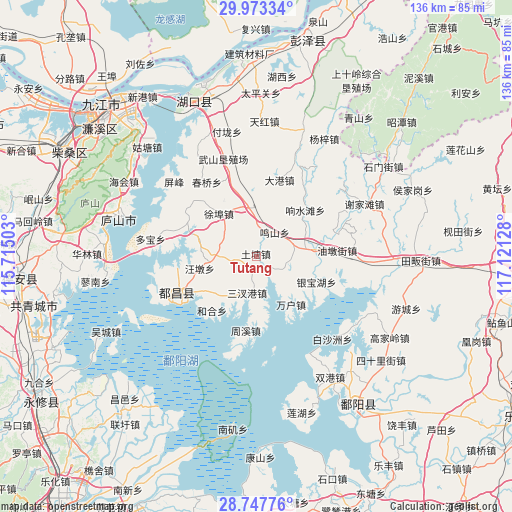
Tutang GPS coordinates[2]
29° 21' 44.604" North, 116° 25' 5.34" East
| Map corner | latitude | longitude |
|---|---|---|
| Upper-left | 29.97334°, | 115.71503° |
| Center: | 29.36239°, | 116.41815° |
| Lower-right: | 28.74776°, | 117.12128° |
| Map W x H: | 136.3×136.3 km | = 84.7×84.7mi |
| max Lat: | 53.31946° ⇑61.2% North |
| Tutang: | 29.36239° |
| min Lat: | ⇓38.8% South 18.22056° |
| min Long | Tutang | max Long |
| 75.07348° | 116.41815° | 134.28917° |
| W 62.6%⇐ | ⇒37.4% E |
Elevation
Elevation of Tutang is 19 m = 62 ft, and this is 465.8 m = 1528 ft below average elevation for this country.
| Max E: |
5622 m = 18445 ft | 83.4% |
| Avg. | 484.8 m = 1591 ft | |
| Tutang | 19 m = 62 ft | |
Min E: |
-3 m = -10 ft | 16.6% |
See also: China elevation on elevation.city.
Geographical zone
Tutang is located in North temperate zone (between Tropic of Cancer and the Arctic Circle). Distance of this Northern Tropic circle is 658.9 km =409.4 mi to South.| Distance of | km | miles | from Tutang |
|---|---|---|---|
| North Pole | 6742.3 | 4189.5 | to North |
| Arctic Circle | 4136.4 | 2570.2 | to North |
| Tropic Cancer | 658.9 | 409.4 | to South |
| Equator | 3264.8 | 2028.7 | to South |


Nearby cities:
15 places around Tutang: (largest is in red/bold)
• Cailing
15.7 km =9.8 mi,  346°
346°
• Dasha
14 km =8.7 mi,  218°
218°
• Dashu
17.8 km =11.1 mi,  238°
238°
• Mingshan
7.9 km =4.9 mi,  34°
34°
• Nanfeng
17.7 km =11 mi,  128°
128°
• Sanchagang
10.2 km =6.3 mi,  195°
195°
• Shishan
6.3 km =3.9 mi,  91°
91°
• Wangdun
15.3 km =9.5 mi,  259°
259°
• Wanhu
16 km =9.9 mi,  144°
144°
• Xiangshuitang
17.9 km =11.1 mi,  45°
45°
• Xiyuan
16.3 km =10.1 mi,  178°
178°
• Xubu
15.1 km =9.4 mi,  318°
318°
• Yangfeng
8.8 km =5.5 mi,  206°
206°
• Yinbaohu
17.5 km =10.9 mi,  116°
116°
• Zhongguan
11.3 km =7 mi,  77°
77°
Sources, notices
• [Note1] Compared only with cities in China existing in our database
• [Src1] Map data: © OpenStreetMap contributors (CC-BY-SA)
• [Src2] Other city data from geonames.org with taken over terms of usage.
• [Src3] Geographical zone / Annual Mean Temperature by Robert A. Rohde @ Wikipedia
