Sanchagang geodata
Sanchagang (Jiangxi) is a seat of a fourth-order administrative division; located in China in Asia/Shanghai (GMT+8) time zone. In our database, there are 1268 cities with bigger population. Compared to other cities in China, 62.3% of cities are located further ↑North; 62.4% of cities are located further ←West and 82.9% of cities have higher elevation than Sanchagang. Note1


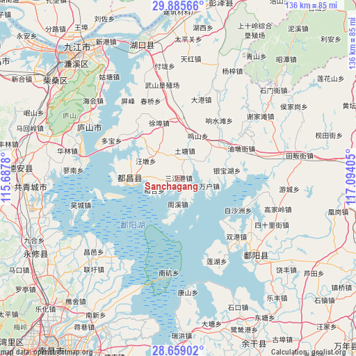
Sanchagang GPS coordinates[2]
29° 16' 27.048" North, 116° 23' 27.312" East
| Map corner | latitude | longitude |
|---|---|---|
| Upper-left | 29.88566°, | 115.6878° |
| Center: | 29.27418°, | 116.39092° |
| Lower-right: | 28.65902°, | 117.09405° |
| Map W x H: | 136.4×136.4 km | = 84.8×84.8mi |
| max Lat: | 53.31946° ⇑62.3% North |
| Sanchagang: | 29.27418° |
| min Lat: | ⇓37.7% South 18.22056° |
| min Long | Sanchagang | max Long |
| 75.07348° | 116.39092° | 134.28917° |
| W 62.4%⇐ | ⇒37.6% E |
Elevation
Elevation of Sanchagang is 20 m = 66 ft, and this is 464.8 m = 1525 ft below average elevation for this country.
| Max E: |
5622 m = 18445 ft | 82.9% |
| Avg. | 484.8 m = 1591 ft | |
| Sanchagang | 20 m = 66 ft | |
Min E: |
-3 m = -10 ft | 17.1% |
See also: China elevation on elevation.city.
Geographical zone
Sanchagang is located in North temperate zone (between Tropic of Cancer and the Arctic Circle). Distance of this Northern Tropic circle is 649.1 km =403.3 mi to South.| Distance of | km | miles | from Sanchagang |
|---|---|---|---|
| North Pole | 6752.1 | 4195.6 | to North |
| Arctic Circle | 4146.2 | 2576.3 | to North |
| Tropic Cancer | 649.1 | 403.3 | to South |
| Equator | 3255 | 2022.6 | to South |


Nearby cities:
15 places around Sanchagang: (largest is in red/bold)
• Dasha
6.2 km =3.9 mi,  260°
260°
• Dashu
12.5 km =7.8 mi,  271°
271°
• Hehe
10.5 km =6.5 mi,  242°
242°
• Mingshan
17.8 km =11.1 mi,  23°
23°
• Nanfeng
16.6 km =10.3 mi,  94°
94°
• Shishan
13.1 km =8.1 mi,  42°
42°
• Tutang
10.2 km =6.3 mi, 15°
• Wangdun
14.3 km =8.9 mi,  299°
299°
• Wanhu
12.3 km =7.6 mi,  105°
105°
• Xiangxi
15.7 km =9.8 mi,  103°
103°
• Xiyuan
7.2 km =4.5 mi,  154°
154°
• Yangfeng
2.3 km =1.4 mi,  325°
325°
• Yinbaohu
18.4 km =11.4 mi,  84°
84°
• Zhongguan
18.4 km =11.4 mi,  48°
48°
• Zhouxi
9.8 km =6.1 mi,  180°
180°
Sources, notices
• [Note1] Compared only with cities in China existing in our database
• [Src1] Map data: © OpenStreetMap contributors (CC-BY-SA)
• [Src2] Other city data from geonames.org with taken over terms of usage.
• [Src3] Geographical zone / Annual Mean Temperature by Robert A. Rohde @ Wikipedia
