Tong’an geodata
Tong’an (Jiangxi) is a seat of a fourth-order administrative division; located in China in Asia/Shanghai (GMT+8) time zone. In our database, there are 1268 cities with bigger population. Compared to other cities in China, 69.2% of cities are located further ↑North; 53.6% of cities are located further ←West and 58.9% of cities have higher elevation than Tong’an. Note1


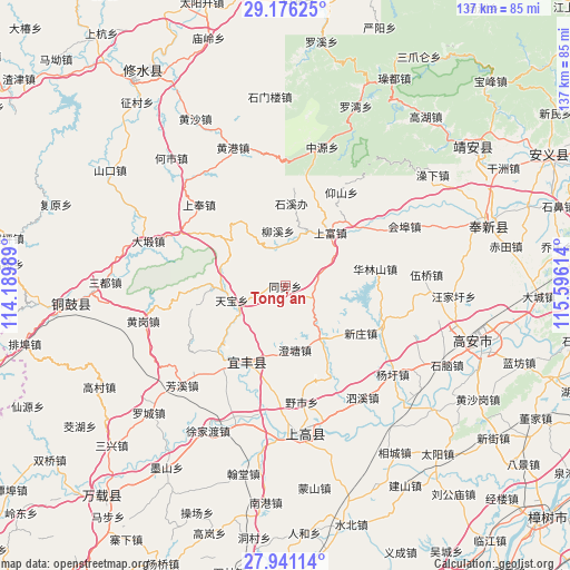
Tong’an GPS coordinates[2]
28° 33' 37.836" North, 114° 53' 34.836" East
| Map corner | latitude | longitude |
|---|---|---|
| Upper-left | 29.17625°, | 114.18989° |
| Center: | 28.56051°, | 114.89301° |
| Lower-right: | 27.94114°, | 115.59614° |
| Map W x H: | 137.3×137.3 km | = 85.3×85.3mi |
| max Lat: | 53.31946° ⇑69.2% North |
| Tong’an: | 28.56051° |
| min Lat: | ⇓30.8% South 18.22056° |
| min Long | Tong’an | max Long |
| 75.07348° | 114.89301° | 134.28917° |
| W 53.6%⇐ | ⇒46.4% E |
Elevation
Elevation of Tong’an is 105 m = 344 ft, and this is 379.8 m = 1246 ft below average elevation for this country.
| Max E: |
5622 m = 18445 ft | 58.9% |
| Avg. | 484.8 m = 1591 ft | |
| Tong’an | 105 m = 344 ft | |
Min E: |
-3 m = -10 ft | 41.1% |
See also: China elevation on elevation.city.
Geographical zone
Tong’an is located in North temperate zone (between Tropic of Cancer and the Arctic Circle). Distance of this Northern Tropic circle is 569.7 km =354 mi to South.| Distance of | km | miles | from Tong’an |
|---|---|---|---|
| North Pole | 6831.4 | 4244.8 | to North |
| Arctic Circle | 4225.5 | 2625.6 | to North |
| Tropic Cancer | 569.7 | 354 | to South |
| Equator | 3175.6 | 1973.2 | to South |


Nearby cities:
15 places around Tong’an: (largest is in red/bold)
• Aoqiao
19.9 km =12.4 mi,  205°
205°
• Chengtang
15.4 km =9.6 mi,  172°
172°
• Cunqian
25.4 km =15.8 mi,  113°
113°
• Ganfang
9.5 km =5.9 mi,  343°
343°
• Huaqiao
7.1 km =4.4 mi, 113°
• Liutou
13.5 km =8.4 mi,  351°
351°
• Luoshi
21.8 km =13.5 mi,  51°
51°
• Qiaoxi
22.6 km =14 mi, 212°
• Shangfu
16.8 km =10.4 mi,  40°
40°
• Shixi
20 km =12.4 mi,  4°
4°
• Tangpu
15.8 km =9.8 mi,  145°
145°
• Tanshan
13.9 km =8.6 mi,  262°
262°
• Tianbao
13.3 km =8.3 mi, 255°
• Xinzhuang
21.5 km =13.4 mi,  121°
121°
• Zaoxi
22.3 km =13.9 mi,  17°
17°
Sources, notices
• [Note1] Compared only with cities in China existing in our database
• [Src1] Map data: © OpenStreetMap contributors (CC-BY-SA)
• [Src2] Other city data from geonames.org with taken over terms of usage.
• [Src3] Geographical zone / Annual Mean Temperature by Robert A. Rohde @ Wikipedia
