Chengtang geodata
Chengtang (Jiangxi) is a seat of a fourth-order administrative division; located in China in Asia/Shanghai (GMT+8) time zone. In our database, there are 1268 cities with bigger population. Compared to other cities in China, 70.4% of cities are located further ↑North; 53.8% of cities are located further ←West and 60.9% of cities have higher elevation than Chengtang. Note1


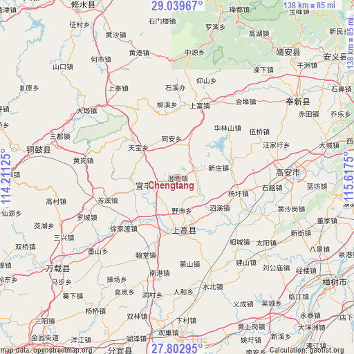
Chengtang GPS coordinates[2]
28° 25' 23.232" North, 114° 54' 51.732" East
| Map corner | latitude | longitude |
|---|---|---|
| Upper-left | 29.03967°, | 114.21125° |
| Center: | 28.42312°, | 114.91437° |
| Lower-right: | 27.80295°, | 115.6175° |
| Map W x H: | 137.5×137.5 km | = 85.4×85.4mi |
| max Lat: | 53.31946° ⇑70.4% North |
| Chengtang: | 28.42312° |
| min Lat: | ⇓29.6% South 18.22056° |
| min Long | Chengtang | max Long |
| 75.07348° | 114.91437° | 134.28917° |
| W 53.8%⇐ | ⇒46.2% E |
Elevation
Elevation of Chengtang is 93 m = 305 ft, and this is 391.8 m = 1285 ft below average elevation for this country.
| Max E: |
5622 m = 18445 ft | 60.9% |
| Avg. | 484.8 m = 1591 ft | |
| Chengtang | 93 m = 305 ft | |
Min E: |
-3 m = -10 ft | 39.1% |
See also: China elevation on elevation.city.
Geographical zone
Chengtang is located in North temperate zone (between Tropic of Cancer and the Arctic Circle). Distance of this Northern Tropic circle is 554.4 km =344.5 mi to South.| Distance of | km | miles | from Chengtang |
|---|---|---|---|
| North Pole | 6846.7 | 4254.3 | to North |
| Arctic Circle | 4240.8 | 2635.1 | to North |
| Tropic Cancer | 554.4 | 344.5 | to South |
| Equator | 3160.4 | 1963.8 | to South |


Nearby cities:
15 places around Chengtang: (largest is in red/bold)
• Aoqiao
11.1 km =6.9 mi,  256°
256°
• Aoshan
19 km =11.8 mi,  160°
160°
• Aoyang
20.5 km =12.7 mi,  178°
178°
• Cunqian
21.9 km =13.6 mi,  76°
76°
• Huaqiao
13.2 km =8.2 mi,  19°
19°
• Jinjiang
21.2 km =13.2 mi, 183°
• Qiaoxi
14.7 km =9.1 mi,  254°
254°
• Sixi
20.4 km =12.7 mi,  126°
126°
• Tangpu
7.3 km =4.5 mi,  71°
71°
• Tanshan
20.8 km =12.9 mi,  310°
310°
• Taxia
22.8 km =14.2 mi,  171°
171°
• Tianbao
19.1 km =11.9 mi, 308°
• Tong’an
15.4 km =9.6 mi,  352°
352°
• Xinzhuang
16.6 km =10.3 mi, 76°
• Yeshi
12.8 km =8 mi, 171°
Sources, notices
• [Note1] Compared only with cities in China existing in our database
• [Src1] Map data: © OpenStreetMap contributors (CC-BY-SA)
• [Src2] Other city data from geonames.org with taken over terms of usage.
• [Src3] Geographical zone / Annual Mean Temperature by Robert A. Rohde @ Wikipedia
