Tengtian geodata
Tengtian (Jiangxi) is a seat of a fourth-order administrative division; located in China in Asia/Shanghai (GMT+8) time zone. In our database, there are 1268 cities with bigger population. Compared to other cities in China, 78.3% of cities are located further ↑North; 57.9% of cities are located further ←West and 56% of cities have higher elevation than Tengtian. Note1


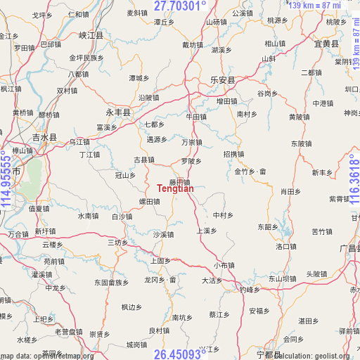
Tengtian GPS coordinates[2]
27° 4' 43.392" North, 115° 39' 31.212" East
| Map corner | latitude | longitude |
|---|---|---|
| Upper-left | 27.70301°, | 114.95555° |
| Center: | 27.07872°, | 115.65867° |
| Lower-right: | 26.45093°, | 116.3618° |
| Map W x H: | 139.2×139.2 km | = 86.5×86.5mi |
| max Lat: | 53.31946° ⇑78.3% North |
| Tengtian: | 27.07872° |
| min Lat: | ⇓21.7% South 18.22056° |
| min Long | Tengtian | max Long |
| 75.07348° | 115.65867° | 134.28917° |
| W 57.9%⇐ | ⇒42.1% E |
Elevation
Elevation of Tengtian is 124 m = 407 ft, and this is 360.8 m = 1184 ft below average elevation for this country.
| Max E: |
5622 m = 18445 ft | 56% |
| Avg. | 484.8 m = 1591 ft | |
| Tengtian | 124 m = 407 ft | |
Min E: |
-3 m = -10 ft | 44% |
See also: China elevation on elevation.city.
Geographical zone
Tengtian is located in North temperate zone (between Tropic of Cancer and the Arctic Circle). Distance of this Northern Tropic circle is 405 km =251.7 mi to South.| Distance of | km | miles | from Tengtian |
|---|---|---|---|
| North Pole | 6996.2 | 4347.2 | to North |
| Arctic Circle | 4390.3 | 2728 | to North |
| Tropic Cancer | 405 | 251.7 | to South |
| Equator | 3010.9 | 1870.9 | to South |


Nearby cities:
15 places around Tengtian: (largest is in red/bold)
• Guanshan
21.2 km =13.2 mi,  276°
276°
• Guxian
16.4 km =10.2 mi,  300°
300°
• Huping
15.5 km =9.6 mi,  34°
34°
• Jinzhu
23.9 km =14.9 mi,  105°
105°
• Luobei
9.1 km =5.7 mi, 28°
• Luotian
13.9 km =8.6 mi,  238°
238°
• Qidu
24.1 km =15 mi,  335°
335°
• Shangxi
21.6 km =13.4 mi,  151°
151°
• Shaxi
21.6 km =13.4 mi,  197°
197°
• Shima
12.4 km =7.7 mi,  137°
137°
• Taotang
3.5 km =2.2 mi, 110°
• Wanchong
15.5 km =9.6 mi,  15°
15°
• Yaotian
6.8 km =4.2 mi,  326°
326°
• Zhaoxie
23.2 km =14.4 mi,  64°
64°
• Zhongcun
21.3 km =13.2 mi,  128°
128°
Sources, notices
• [Note1] Compared only with cities in China existing in our database
• [Src1] Map data: © OpenStreetMap contributors (CC-BY-SA)
• [Src2] Other city data from geonames.org with taken over terms of usage.
• [Src3] Geographical zone / Annual Mean Temperature by Robert A. Rohde @ Wikipedia
