Wanchong geodata
Wanchong (Jiangxi) is a seat of a fourth-order administrative division; located in China in Asia/Shanghai (GMT+8) time zone. In our database, there are 1268 cities with bigger population. Compared to other cities in China, 77.7% of cities are located further ↑North; 58.1% of cities are located further ←West and 57.9% of cities have higher elevation than Wanchong. Note1


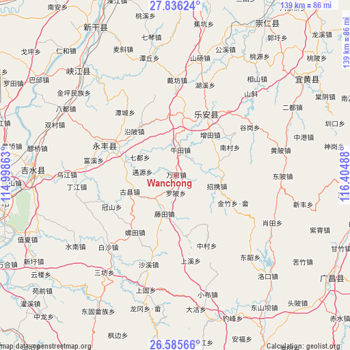
Wanchong GPS coordinates[2]
27° 12' 45.72" North, 115° 42' 6.3" East
| Map corner | latitude | longitude |
|---|---|---|
| Upper-left | 27.83624°, | 114.99863° |
| Center: | 27.2127°, | 115.70175° |
| Lower-right: | 26.58566°, | 116.40488° |
| Map W x H: | 139.1×139.1 km | = 86.4×86.4mi |
| max Lat: | 53.31946° ⇑77.7% North |
| Wanchong: | 27.2127° |
| min Lat: | ⇓22.3% South 18.22056° |
| min Long | Wanchong | max Long |
| 75.07348° | 115.70175° | 134.28917° |
| W 58.1%⇐ | ⇒41.9% E |
Elevation
Elevation of Wanchong is 112 m = 367 ft, and this is 372.8 m = 1223 ft below average elevation for this country.
| Max E: |
5622 m = 18445 ft | 57.9% |
| Avg. | 484.8 m = 1591 ft | |
| Wanchong | 112 m = 367 ft | |
Min E: |
-3 m = -10 ft | 42.1% |
See also: China elevation on elevation.city.
Geographical zone
Wanchong is located in North temperate zone (between Tropic of Cancer and the Arctic Circle). Distance of this Northern Tropic circle is 419.8 km =260.9 mi to South.| Distance of | km | miles | from Wanchong |
|---|---|---|---|
| North Pole | 6981.3 | 4338 | to North |
| Arctic Circle | 4375.4 | 2718.7 | to North |
| Tropic Cancer | 419.8 | 260.9 | to South |
| Equator | 3025.8 | 1880.1 | to South |


Nearby cities:
15 places around Wanchong: (largest is in red/bold)
• Guxian
19.6 km =12.2 mi,  250°
250°
• Huping
5.1 km =3.2 mi,  115°
115°
• Lugang
22.9 km =14.2 mi,  338°
338°
• Luobei
6.9 km =4.3 mi,  178°
178°
• Nancun
24.1 km =15 mi,  63°
63°
• Niutian
10.1 km =6.3 mi,  12°
12°
• Qidu
16 km =9.9 mi,  295°
295°
• Tangang
23.3 km =14.5 mi, 12°
• Taotang
16.1 km =10 mi, 183°
• Tengtian
15.5 km =9.6 mi,  195°
195°
• Wangxian
17.5 km =10.9 mi,  73°
73°
• Yanbei
24.2 km =15 mi,  316°
316°
• Yaotian
12.2 km =7.6 mi,  220°
220°
• Zengtian
20.9 km =13 mi,  40°
40°
• Zhaoxie
17.4 km =10.8 mi,  106°
106°
Sources, notices
• [Note1] Compared only with cities in China existing in our database
• [Src1] Map data: © OpenStreetMap contributors (CC-BY-SA)
• [Src2] Other city data from geonames.org with taken over terms of usage.
• [Src3] Geographical zone / Annual Mean Temperature by Robert A. Rohde @ Wikipedia
