Taishan geodata
Taishan (Guangdong) is a seat of a third-order administrative division; located in China in Asia/Shanghai (GMT+8) time zone. With population of 145,440 people, there are 307 cities with bigger population in this country. Compared to other cities in China, 96.9% of cities are located further ↑North; 58.8% of cities are located further →East and 98.9% of cities have higher elevation than Taishan. Note1


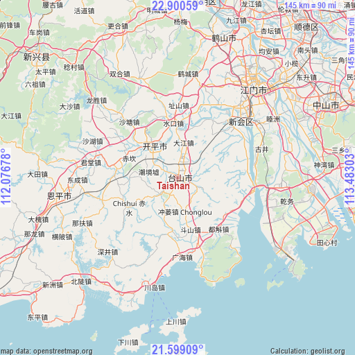
Taishan GPS coordinates[2]
22° 15' 4.86" North, 112° 46' 47.64" East
| Map corner | latitude | longitude |
|---|---|---|
| Upper-left | 22.90059°, | 112.07678° |
| Center: | 22.25135°, | 112.7799° |
| Lower-right: | 21.59909°, | 113.48303° |
| Map W x H: | 144.7×144.7 km | = 89.9×89.9mi |
| max Lat: | 53.31946° ⇑96.9% North |
| Taishan: | 22.25135° |
| min Lat: | ⇓3.1% South 18.22056° |
| min Long | Taishan | max Long |
| 75.07348° | 112.7799° | 134.28917° |
| W 41.2%⇐ | ⇒58.8% E |
Elevation
Elevation of Taishan is 3 m = 10 ft, and this is 481.8 m = 1581 ft below average elevation for this country.
| Max E: |
5622 m = 18445 ft | 98.9% |
| Avg. | 484.8 m = 1591 ft | |
| Taishan | 3 m = 10 ft | |
Min E: |
-3 m = -10 ft | 1.1% |
See also: Taishan elevation on elevation.city.
Geographical zone
Taishan is located in North Torrid zone (between Equator and Tropic of Cancer). Distance of this Northern Tropic circle is 131.8 km =81.9 mi to North.| Distance of | km | miles | from Taishan |
|---|---|---|---|
| North Pole | 7532.9 | 4680.7 | to North |
| Arctic Circle | 4927.1 | 3061.6 | to North |
| Tropic Cancer | 131.8 | 81.9 | to North |
| Equator | 2474.1 | 1537.3 | to South |


Nearby cities:
15 places around Taishan: (largest is in red/bold)
• Baisha
19.2 km =11.9 mi,  269°
269°
• Changsha
17.4 km =10.8 mi,  325°
325°
• Chikan
21.9 km =13.6 mi,  291°
291°
• Chishui
23.3 km =14.5 mi,  238°
238°
• Chonglou
13.8 km =8.6 mi,  168°
168°
• Dajiang
14.1 km =8.8 mi,  8°
8°
• Doushan
21.6 km =13.4 mi, 165°
• Duanfen
21.6 km =13.4 mi,  187°
187°
• Sanba
11.6 km =7.2 mi,  298°
298°
• Sanbu
15.5 km =9.6 mi,  322°
322°
• Sanhe
9.3 km =5.8 mi,  223°
223°
• Shuibu
9.6 km =6 mi, 13°
• Shuikou
22.7 km =14.1 mi,  355°
355°
• Sijiu
9.3 km =5.8 mi,  120°
120°
• Tangkou
21.2 km =13.2 mi,  307°
307°
Sources, notices
• [Note1] Compared only with cities in China existing in our database
• [Src1] Map data: © OpenStreetMap contributors (CC-BY-SA)
• [Src2] Other city data from geonames.org with taken over terms of usage.
• [Src3] Geographical zone / Annual Mean Temperature by Robert A. Rohde @ Wikipedia
