Shuikou geodata
Shuikou (Guangdong) is a seat of a fourth-order administrative division; located in China in Asia/Shanghai (GMT+8) time zone. In our database, there are 1268 cities with bigger population. Compared to other cities in China, 96.5% of cities are located further ↑North; 58.8% of cities are located further →East and 91.2% of cities have higher elevation than Shuikou. Note1


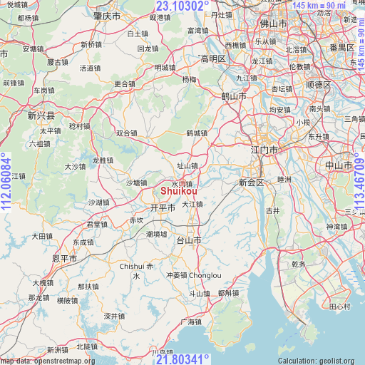
Shuikou GPS coordinates[2]
22° 27' 17.064" North, 112° 45' 50.256" East
| Map corner | latitude | longitude |
|---|---|---|
| Upper-left | 23.10302°, | 112.06084° |
| Center: | 22.45474°, | 112.76396° |
| Lower-right: | 21.80341°, | 113.46709° |
| Map W x H: | 144.5×144.5 km | = 89.8×89.8mi |
| max Lat: | 53.31946° ⇑96.5% North |
| Shuikou: | 22.45474° |
| min Lat: | ⇓3.5% South 18.22056° |
| min Long | Shuikou | max Long |
| 75.07348° | 112.76396° | 134.28917° |
| W 41.2%⇐ | ⇒58.8% E |
Elevation
Elevation of Shuikou is 9 m = 30 ft, and this is 475.8 m = 1561 ft below average elevation for this country.
| Max E: |
5622 m = 18445 ft | 91.2% |
| Avg. | 484.8 m = 1591 ft | |
| Shuikou | 9 m = 30 ft | |
Min E: |
-3 m = -10 ft | 8.8% |
See also: China elevation on elevation.city.
Geographical zone
Shuikou is located in North Torrid zone (between Equator and Tropic of Cancer). Distance of this Northern Tropic circle is 109.2 km =67.9 mi to North.| Distance of | km | miles | from Shuikou |
|---|---|---|---|
| North Pole | 7510.3 | 4666.7 | to North |
| Arctic Circle | 4904.4 | 3047.5 | to North |
| Tropic Cancer | 109.2 | 67.9 | to North |
| Equator | 2496.7 | 1551.4 | to South |


Nearby cities:
15 places around Shuikou: (largest is in red/bold)
• Changsha
11.5 km =7.1 mi,  224°
224°
• Dajiang
9.4 km =5.8 mi,  156°
156°
• Daze
18.9 km =11.7 mi,  67°
67°
• Gonghe
18.3 km =11.4 mi,  39°
39°
• Hecheng
21.2 km =13.2 mi,  14°
14°
• Luokeng
16 km =9.9 mi,  86°
86°
• Sanba
19 km =11.8 mi,  206°
206°
• Sanbu
13 km =8.1 mi, 217°
• Shatang
18.2 km =11.3 mi,  271°
271°
• Shuibu
13.8 km =8.6 mi, 163°
• Siqian
10.3 km =6.4 mi,  64°
64°
• Tangkou
17.9 km =11.1 mi,  237°
237°
• Yueshan
4.5 km =2.8 mi,  305°
305°
• Yunxiang
12.3 km =7.6 mi,  357°
357°
• Zhishan
7.3 km =4.5 mi,  16°
16°
Sources, notices
• [Note1] Compared only with cities in China existing in our database
• [Src1] Map data: © OpenStreetMap contributors (CC-BY-SA)
• [Src2] Other city data from geonames.org with taken over terms of usage.
• [Src3] Geographical zone / Annual Mean Temperature by Robert A. Rohde @ Wikipedia
