Niudaokou geodata
Niudaokou (Tianjin) is a populated place; located in China in Asia/Shanghai (GMT+8) time zone. With population of 2,108 people, there are 1024 cities with bigger population in this country. Compared to other cities in China, 85.6% of cities are located further ↓South; 67.5% of cities are located further ←West and 89.9% of cities have higher elevation than Niudaokou. Note1


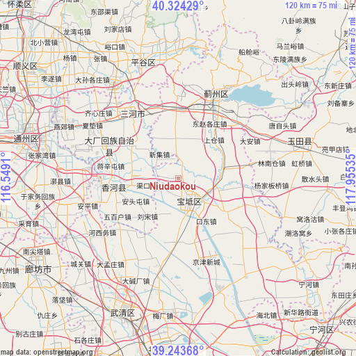
Niudaokou GPS coordinates[2]
39° 47' 9.996" North, 117° 15' 7.992" East
| Map corner | latitude | longitude |
|---|---|---|
| Upper-left | 40.32429°, | 116.5491° |
| Center: | 39.78611°, | 117.25222° |
| Lower-right: | 39.24368°, | 117.95535° |
| Map W x H: | 120.2×120.2 km | = 74.7×74.7mi |
| max Lat: | 53.31946° ⇑14.4% North |
| Niudaokou: | 39.78611° |
| min Lat: | ⇓85.6% South 18.22056° |
| min Long | Niudaokou | max Long |
| 75.07348° | 117.25222° | 134.28917° |
| W 67.5%⇐ | ⇒32.5% E |
Elevation
Elevation of Niudaokou is 10 m = 33 ft, and this is 474.8 m = 1558 ft below average elevation for this country.
| Max E: |
5622 m = 18445 ft | 89.9% |
| Avg. | 484.8 m = 1591 ft | |
| Niudaokou | 10 m = 33 ft | |
Min E: |
-3 m = -10 ft | 10.1% |
See also: China elevation on elevation.city.
Geographical zone
Niudaokou is located in North temperate zone (between Tropic of Cancer and the Arctic Circle). Distance of this Northern Tropic circle is 1817.9 km =1129.6 mi to South.| Distance of | km | miles | from Niudaokou |
|---|---|---|---|
| North Pole | 5583.3 | 3469.3 | to North |
| Arctic Circle | 2977.4 | 1850.1 | to North |
| Tropic Cancer | 1817.9 | 1129.6 | to South |
| Equator | 4423.8 | 2748.8 | to South |


Nearby cities:
15 places around Niudaokou: (largest is in red/bold)
• Dayanggezhuang
15.1 km =9.4 mi,  76°
76°
• Dongshigu
12.3 km =7.6 mi,  32°
32°
• Dongtazhuang
14 km =8.7 mi, 31°
• Goutou
5 km =3.1 mi,  294°
294°
• Huogezhuang
10.9 km =6.8 mi,  115°
115°
• Liuzikou
12.4 km =7.7 mi,  40°
40°
• Majiadian
14.3 km =8.9 mi,  175°
175°
• Panggezhuang
7.6 km =4.7 mi, 285°
• Sanchakou
5.7 km =3.5 mi,  91°
91°
• Shiqiao
11.2 km =7 mi,  160°
160°
• Xiacang
14.1 km =8.8 mi, 89°
• Xinkaikou
13 km =8.1 mi,  203°
203°
• Youguzhuang
13.3 km =8.3 mi,  357°
357°
• Zhaogezhuang
4.8 km =3 mi,  267°
267°
• Zhuangtou
14.7 km =9.1 mi,  166°
166°
Sources, notices
• [Note1] Compared only with cities in China existing in our database
• [Src1] Map data: © OpenStreetMap contributors (CC-BY-SA)
• [Src2] Other city data from geonames.org with taken over terms of usage.
• [Src3] Geographical zone / Annual Mean Temperature by Robert A. Rohde @ Wikipedia
