Nanxiashu geodata
Nanxiashu (Jiangsu) is a seat of a fourth-order administrative division; located in China in Asia/Shanghai (GMT+8) time zone. In our database, there are 1268 cities with bigger population. Compared to other cities in China, 59.1% of cities are located further ↓South; 81.5% of cities are located further ←West and 91.2% of cities have higher elevation than Nanxiashu. Note1


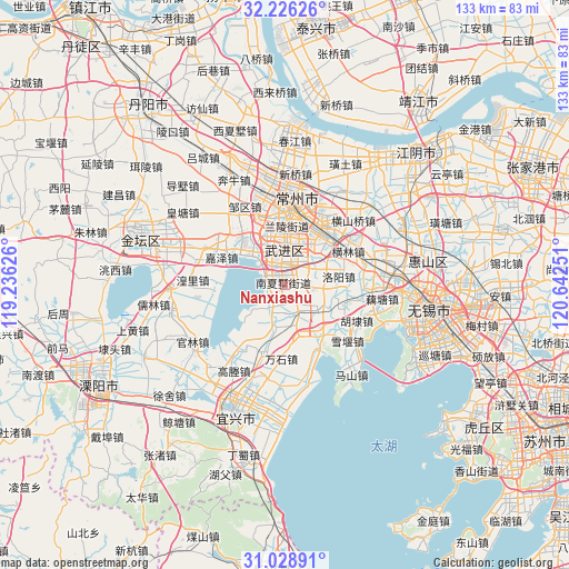
Nanxiashu GPS coordinates[2]
31° 37' 46.236" North, 119° 56' 21.768" East
| Map corner | latitude | longitude |
|---|---|---|
| Upper-left | 32.22626°, | 119.23626° |
| Center: | 31.62951°, | 119.93938° |
| Lower-right: | 31.02891°, | 120.64251° |
| Map W x H: | 133.1×133.1 km | = 82.7×82.7mi |
| max Lat: | 53.31946° ⇑40.9% North |
| Nanxiashu: | 31.62951° |
| min Lat: | ⇓59.1% South 18.22056° |
| min Long | Nanxiashu | max Long |
| 75.07348° | 119.93938° | 134.28917° |
| W 81.5%⇐ | ⇒18.5% E |
Elevation
Elevation of Nanxiashu is 9 m = 30 ft, and this is 475.8 m = 1561 ft below average elevation for this country.
| Max E: |
5622 m = 18445 ft | 91.2% |
| Avg. | 484.8 m = 1591 ft | |
| Nanxiashu | 9 m = 30 ft | |
Min E: |
-3 m = -10 ft | 8.8% |
See also: China elevation on elevation.city.
Geographical zone
Nanxiashu is located in North temperate zone (between Tropic of Cancer and the Arctic Circle). Distance of this Northern Tropic circle is 911 km =566.1 mi to South.| Distance of | km | miles | from Nanxiashu |
|---|---|---|---|
| North Pole | 6490.2 | 4032.8 | to North |
| Arctic Circle | 3884.3 | 2413.6 | to North |
| Tropic Cancer | 911 | 566.1 | to South |
| Equator | 3516.9 | 2185.3 | to South |


Nearby cities:
15 places around Nanxiashu: (largest is in red/bold)
• Changzhou
16.1 km =10 mi,  4°
4°
• Dingyan
14.6 km =9.1 mi,  27°
27°
• Henglin
16.6 km =10.3 mi,  62°
62°
• Heqiao
16.9 km =10.5 mi,  197°
197°
• Hutang
9.6 km =6 mi, 2°
• Jiaze
15.9 km =9.9 mi,  293°
293°
• Lijia
6.7 km =4.2 mi,  89°
89°
• Luoyang
13.1 km =8.1 mi,  81°
81°
• Niutang
12.4 km =7.7 mi,  339°
339°
• Qianhuang
4.2 km =2.6 mi,  150°
150°
• Qishuyan
15.4 km =9.6 mi,  44°
44°
• Wanshi
17.1 km =10.6 mi,  183°
183°
• Xilin
16.3 km =10.1 mi, 342°
• Yangshan
15.1 km =9.4 mi,  111°
111°
• Yaoguan
11.6 km =7.2 mi,  48°
48°
Sources, notices
• [Note1] Compared only with cities in China existing in our database
• [Src1] Map data: © OpenStreetMap contributors (CC-BY-SA)
• [Src2] Other city data from geonames.org with taken over terms of usage.
• [Src3] Geographical zone / Annual Mean Temperature by Robert A. Rohde @ Wikipedia
