Madian geodata
Madian (Jiangsu) is a seat of a fourth-order administrative division; located in China in Asia/Shanghai (GMT+8) time zone. In our database, there are 1268 cities with bigger population. Compared to other cities in China, 62.6% of cities are located further ↓South; 81.7% of cities are located further ←West and 92.7% of cities have higher elevation than Madian. Note1


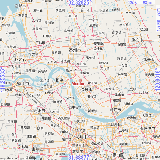
Madian GPS coordinates[2]
32° 14' 7.656" North, 119° 57' 30.492" East
| Map corner | latitude | longitude |
|---|---|---|
| Upper-left | 32.82825°, | 119.25535° |
| Center: | 32.23546°, | 119.95847° |
| Lower-right: | 31.63877°, | 120.6616° |
| Map W x H: | 132.3×132.3 km | = 82.2×82.2mi |
| max Lat: | 53.31946° ⇑37.4% North |
| Madian: | 32.23546° |
| min Lat: | ⇓62.6% South 18.22056° |
| min Long | Madian | max Long |
| 75.07348° | 119.95847° | 134.28917° |
| W 81.7%⇐ | ⇒18.3% E |
Elevation
Elevation of Madian is 8 m = 26 ft, and this is 476.8 m = 1564 ft below average elevation for this country.
| Max E: |
5622 m = 18445 ft | 92.7% |
| Avg. | 484.8 m = 1591 ft | |
| Madian | 8 m = 26 ft | |
Min E: |
-3 m = -10 ft | 7.3% |
See also: China elevation on elevation.city.
Geographical zone
Madian is located in North temperate zone (between Tropic of Cancer and the Arctic Circle). Distance of this Northern Tropic circle is 978.3 km =607.9 mi to South.| Distance of | km | miles | from Madian |
|---|---|---|---|
| North Pole | 6422.8 | 3990.9 | to North |
| Arctic Circle | 3816.9 | 2371.7 | to North |
| Tropic Cancer | 978.3 | 607.9 | to South |
| Equator | 3584.2 | 2227.1 | to South |


Nearby cities:
15 places around Madian: (largest is in red/bold)
• Dasheng
10.7 km =6.6 mi,  167°
167°
• Dasi
13.7 km =8.5 mi,  4°
4°
• Diaopu
14.7 km =9.1 mi,  327°
327°
• Gensi
5.1 km =3.2 mi,  69°
69°
• Guochuan
10.1 km =6.3 mi,  197°
197°
• Huzhuang
14.2 km =8.8 mi,  24°
24°
• Kou’an
11.2 km =7 mi,  316°
316°
• Minggou
5 km =3.1 mi,  287°
287°
• Sanmao
13.5 km =8.4 mi,  271°
271°
• Taixing
9.2 km =5.7 mi,  145°
145°
• Xinglong
12.2 km =7.6 mi,  238°
238°
• Xuanbao
6.9 km =4.3 mi,  27°
27°
• Xuzhuang
14.3 km =8.9 mi,  340°
340°
• Yaowang
10.4 km =6.5 mi,  101°
101°
• Youfang
16 km =9.9 mi,  222°
222°
Sources, notices
• [Note1] Compared only with cities in China existing in our database
• [Src1] Map data: © OpenStreetMap contributors (CC-BY-SA)
• [Src2] Other city data from geonames.org with taken over terms of usage.
• [Src3] Geographical zone / Annual Mean Temperature by Robert A. Rohde @ Wikipedia
