Youfang geodata
Youfang (Jiangsu) is a seat of a fourth-order administrative division; located in China in Asia/Shanghai (GMT+8) time zone. In our database, there are 1268 cities with bigger population. Compared to other cities in China, 62% of cities are located further ↓South; 80.8% of cities are located further ←West and 94.3% of cities have higher elevation than Youfang. Note1


Youfang GPS coordinates[2]
32° 7' 44.112" North, 119° 50' 39.588" East
| Map corner | latitude | longitude |
|---|---|---|
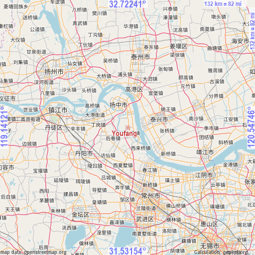
| Upper-left | 32.72241°, | 119.14121° |
| Center: | 32.12892°, | 119.84433° |
| Lower-right: | 31.53154°, | 120.54746° |
| Map W x H: | 132.4×132.4 km | = 82.3×82.3mi |
| max Lat: | 53.31946° ⇑38% North |
| Youfang: | 32.12892° |
| min Lat: | ⇓62% South 18.22056° |
| min Long | Youfang | max Long |
| 75.07348° | 119.84433° | 134.28917° |
| W 80.8%⇐ | ⇒19.2% E |
Elevation
Elevation of Youfang is 7 m = 23 ft, and this is 477.8 m = 1568 ft below average elevation for this country.
| Max E: |
5622 m = 18445 ft | 94.3% |
| Avg. | 484.8 m = 1591 ft | |
| Youfang | 7 m = 23 ft | |
Min E: |
-3 m = -10 ft | 5.7% |
See also: China elevation on elevation.city.
Geographical zone
Youfang is located in North temperate zone (between Tropic of Cancer and the Arctic Circle). Distance of this Northern Tropic circle is 966.5 km =600.6 mi to South.| Distance of | km | miles | from Youfang |
|---|---|---|---|
| North Pole | 6434.7 | 3998.3 | to North |
| Arctic Circle | 3828.8 | 2379.1 | to North |
| Tropic Cancer | 966.5 | 600.6 | to South |
| Equator | 3572.4 | 2219.8 | to South |


Nearby cities:
15 places around Youfang: (largest is in red/bold)
• Baqiao
3.6 km =2.2 mi,  127°
127°
• Dalu
14.3 km =8.9 mi,  312°
312°
• Dasheng
13.1 km =8.1 mi,  83°
83°
• Dinggang
15.1 km =9.4 mi,  276°
276°
• Guochuan
8 km =5 mi,  74°
74°
• Houxiang
8.3 km =5.2 mi,  249°
249°
• Jiepai
6.3 km =3.9 mi,  172°
172°
• Menghe
12.5 km =7.8 mi,  177°
177°
• Minggou
14.6 km =9.1 mi,  23°
23°
• Picheng
13.3 km =8.3 mi,  265°
265°
• Sanmao
12.6 km =7.8 mi,  347°
347°
• Xilaiqiao
12.1 km =7.5 mi,  147°
147°
• Xinglong
5.5 km =3.4 mi,  3°
3°
• Xinqiao
7 km =4.3 mi,  210°
210°
• Yaoqiao
7.8 km =4.8 mi,  299°
299°
Sources, notices
• [Note1] Compared only with cities in China existing in our database
• [Src1] Map data: © OpenStreetMap contributors (CC-BY-SA)
• [Src2] Other city data from geonames.org with taken over terms of usage.
• [Src3] Geographical zone / Annual Mean Temperature by Robert A. Rohde @ Wikipedia
